Cesate geodata
Cesate (Lombardy) is a seat of a third-order administrative division; located in Italy in Europe/Rome (GMT+2) time zone. With population of 13,531 people, there are 673 cities with bigger population in this country. Compared to other cities in Italy, 76.9% of cities are located further ↓South; 80.1% of cities are located further →East and 56.3% of cities have higher elevation than Cesate. Note1
Administrative division(s):
- Level 1: Lombardy
- Level 2: Città metropolitana di Milano
- Level 3: Cesate


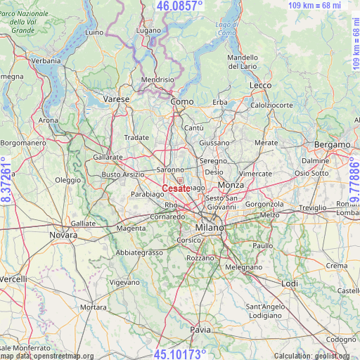
Cesate GPS coordinates[2]
45° 35' 45.132" North, 9° 4' 32.664" East
| Map corner | latitude | longitude |
|---|---|---|
| Upper-left | 46.0857°, | 8.37261° |
| Center: | 45.59587°, | 9.07574° |
| Lower-right: | 45.10173°, | 9.77886° |
| Map W x H: | 109.4×109.4 km | = 68×68mi |
| max Lat: | 47.04031° ⇑23.1% North |
| Cesate: | 45.59587° |
| min Lat: | ⇓76.9% South 35.50142° |
| min Long | Cesate | max Long |
| 6.69888° | 9.07574° | 18.48682° |
| W 19.9%⇐ | ⇒80.1% E |
Elevation
Elevation of Cesate is 193 m = 633 ft, and this is 113.7 m = 373 ft below average elevation for this country.
| Max E: |
2085 m = 6841 ft | 56.3% |
| Avg. | 306.7 m = 1006 ft | |
| Cesate | 193 m = 633 ft | |
Min E: |
-4 m = -13 ft | 43.7% |
See also: Italy elevation on elevation.city.
Geographical zone
Cesate is located in North temperate zone (between Tropic of Cancer and the Arctic Circle). Distance of this North polar circle is 2331.4 km =1448.7 mi to North.| Distance of | km | miles | from Cesate |
|---|---|---|---|
| North Pole | 4937.3 | 3067.9 | to North |
| Arctic Circle | 2331.4 | 1448.7 | to North |
| Tropic Cancer | 2463.9 | 1531 | to South |
| Equator | 5069.8 | 3150.2 | to South |


Nearby cities:
15 places around Cesate: (largest is in red/bold)
• Arese
5 km =3.1 mi,  178°
178°
• Caronno Pertusella
2.3 km =1.4 mi,  275°
275°
• Ceriano Laghetto
3.7 km =2.3 mi,  5°
5°
• Cogliate
5.6 km =3.5 mi,  2°
2°
• Dal Pozzo
4.3 km =2.7 mi,  337°
337°
• Garbagnate Milanese
2.4 km =1.5 mi, 180°
• Lainate
4.7 km =2.9 mi,  234°
234°
• Limbiate
3.9 km =2.4 mi,  83°
83°
• Origgio
4.6 km =2.9 mi,  271°
271°
• Passirana
5.9 km =3.7 mi,  204°
204°
• Saronno
4.5 km =2.8 mi,  315°
315°
• Senago
4.5 km =2.8 mi,  119°
119°
• Solaro
2.1 km =1.3 mi,  15°
15°
• Uboldo
6 km =3.7 mi,  291°
291°
• Villaggio del Sole
3.2 km =2 mi,  50°
50°
Sources, notices
• [Note1] Compared only with cities in Italy existing in our database
• [Src1] Map data: © OpenStreetMap contributors (CC-BY-SA)
• [Src2] Other city data from geonames.org with taken over terms of usage.
• [Src3] Geographical zone / Annual Mean Temperature by Robert A. Rohde @ Wikipedia
