Saronno geodata
Saronno (Lombardy) is a seat of a third-order administrative division; located in Italy in Europe/Rome (GMT+2) time zone. With population of 38,099 people, there are 191 cities with bigger population in this country. Compared to other cities in Italy, 78% of cities are located further ↓South; 80.8% of cities are located further →East and 53.2% of cities have higher elevation than Saronno. Note1


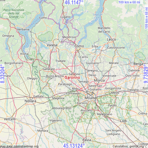
Saronno GPS coordinates[2]
45° 37' 30.468" North, 9° 2' 6.612" East
| Map corner | latitude | longitude |
|---|---|---|
| Upper-left | 46.1147°, | 8.33204° |
| Center: | 45.62513°, | 9.03517° |
| Lower-right: | 45.13124°, | 9.73829° |
| Map W x H: | 109.4×109.3 km | = 68×67.9mi |
| max Lat: | 47.04031° ⇑22% North |
| Saronno: | 45.62513° |
| min Lat: | ⇓78% South 35.50142° |
| min Long | Saronno | max Long |
| 6.69888° | 9.03517° | 18.48682° |
| W 19.2%⇐ | ⇒80.8% E |
Elevation
Elevation of Saronno is 215 m = 705 ft, and this is 91.7 m = 301 ft below average elevation for this country.
| Max E: |
2085 m = 6841 ft | 53.2% |
| Avg. | 306.7 m = 1006 ft | |
| Saronno | 215 m = 705 ft | |
Min E: |
-4 m = -13 ft | 46.8% |
See also: Italy elevation on elevation.city.
Geographical zone
Saronno is located in North temperate zone (between Tropic of Cancer and the Arctic Circle). Distance of this North polar circle is 2328.1 km =1446.6 mi to North.| Distance of | km | miles | from Saronno |
|---|---|---|---|
| North Pole | 4934 | 3065.8 | to North |
| Arctic Circle | 2328.1 | 1446.6 | to North |
| Tropic Cancer | 2467.1 | 1533 | to South |
| Equator | 5073 | 3152.2 | to South |


Nearby cities:
15 places around Saronno: (largest is in red/bold)
• Caronno Pertusella
3.2 km =2 mi,  164°
164°
• Cascina Nuova
3.8 km =2.4 mi,  36°
36°
• Ceriano Laghetto
3.5 km =2.2 mi,  82°
82°
• Cesate
4.5 km =2.8 mi,  135°
135°
• Cogliate
4.1 km =2.5 mi,  55°
55°
• Dal Pozzo
1.7 km =1.1 mi,  65°
65°
• Gerenzano
3.1 km =1.9 mi,  301°
301°
• Manera
5.4 km =3.4 mi,  4°
4°
• Massina
5.2 km =3.2 mi,  294°
294°
• Origgio
3.5 km =2.2 mi,  204°
204°
• Rovellasca
4.7 km =2.9 mi,  12°
12°
• Rovello Porro
3 km =1.9 mi, 6°
• Solaro
3.9 km =2.4 mi,  107°
107°
• Turate
4.3 km =2.7 mi,  326°
326°
• Uboldo
2.7 km =1.7 mi,  245°
245°
Sources, notices
• [Note1] Compared only with cities in Italy existing in our database
• [Src1] Map data: © OpenStreetMap contributors (CC-BY-SA)
• [Src2] Other city data from geonames.org with taken over terms of usage.
• [Src3] Geographical zone / Annual Mean Temperature by Robert A. Rohde @ Wikipedia
