Barbata geodata
Barbata (Lombardy) is a seat of a third-order administrative division; located in Italy in Europe/Rome (GMT+2) time zone. With population of 586 people, there are 9123 cities with bigger population in this country. Compared to other cities in Italy, 72.7% of cities are located further ↓South; 70% of cities are located further →East and 69% of cities have higher elevation than Barbata. Note1


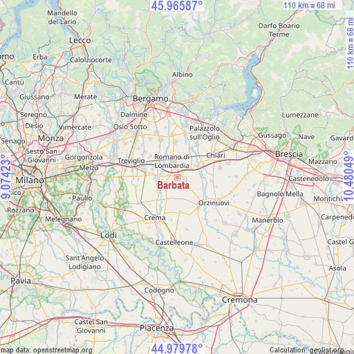
Barbata GPS coordinates[2]
45° 28' 29.928" North, 9° 46' 38.496" East
| Map corner | latitude | longitude |
|---|---|---|
| Upper-left | 45.96587°, | 9.07423° |
| Center: | 45.47498°, | 9.77736° |
| Lower-right: | 44.97978°, | 10.48049° |
| Map W x H: | 109.6×109.6 km | = 68.1×68.1mi |
| max Lat: | 47.04031° ⇑27.3% North |
| Barbata: | 45.47498° |
| min Lat: | ⇓72.7% South 35.50142° |
| min Long | Barbata | max Long |
| 6.69888° | 9.77736° | 18.48682° |
| W 30%⇐ | ⇒70% E |
Elevation
Elevation of Barbata is 103 m = 338 ft, and this is 203.7 m = 668 ft below average elevation for this country.
| Max E: |
2085 m = 6841 ft | 69% |
| Avg. | 306.7 m = 1006 ft | |
| Barbata | 103 m = 338 ft | |
Min E: |
-4 m = -13 ft | 31% |
See also: Italy elevation on elevation.city.
Geographical zone
Barbata is located in North temperate zone (between Tropic of Cancer and the Arctic Circle). Distance of this North polar circle is 2344.8 km =1457 mi to North.| Distance of | km | miles | from Barbata |
|---|---|---|---|
| North Pole | 4950.7 | 3076.2 | to North |
| Arctic Circle | 2344.8 | 1457 | to North |
| Tropic Cancer | 2450.4 | 1522.6 | to South |
| Equator | 5056.3 | 3141.8 | to South |


Nearby cities:
15 places around Barbata: (largest is in red/bold)
• Antegnate
1.7 km =1.1 mi,  40°
40°
• Bottaiano
7.1 km =4.4 mi,  202°
202°
• Calcio
6.7 km =4.2 mi,  56°
56°
• Camisano
4.2 km =2.6 mi,  216°
216°
• Casale Cremasco
6.9 km =4.3 mi,  225°
225°
• Casaletto di Sopra
6.2 km =3.9 mi,  176°
176°
• Castel Gabbiano
4.7 km =2.9 mi,  261°
261°
• Covo
2.7 km =1.7 mi,  348°
348°
• Fara Olivana
3.1 km =1.9 mi,  315°
315°
• Fontanella
2.1 km =1.3 mi,  108°
108°
• Gallignano
6.3 km =3.9 mi,  131°
131°
• Isso
1.5 km =0.9 mi,  277°
277°
• Mozzanica
6.9 km =4.3 mi,  271°
271°
• Pumenengo
7.1 km =4.4 mi,  85°
85°
• Romano di Lombardia
5.4 km =3.4 mi,  340°
340°
Sources, notices
• [Note1] Compared only with cities in Italy existing in our database
• [Src1] Map data: © OpenStreetMap contributors (CC-BY-SA)
• [Src2] Other city data from geonames.org with taken over terms of usage.
• [Src3] Geographical zone / Annual Mean Temperature by Robert A. Rohde @ Wikipedia
