Castelcovati geodata
Castelcovati (Lombardy) is a seat of a third-order administrative division; located in Italy in Europe/Rome (GMT+2) time zone. With population of 6,224 people, there are 1569 cities with bigger population in this country. Compared to other cities in Italy, 73.7% of cities are located further ↓South; 68.3% of cities are located further →East and 66% of cities have higher elevation than Castelcovati. Note1


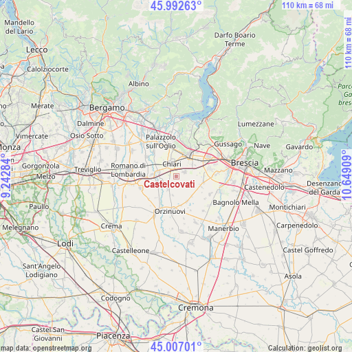
Castelcovati GPS coordinates[2]
45° 30' 7.128" North, 9° 56' 45.456" East
| Map corner | latitude | longitude |
|---|---|---|
| Upper-left | 45.99263°, | 9.24284° |
| Center: | 45.50198°, | 9.94596° |
| Lower-right: | 45.00701°, | 10.64909° |
| Map W x H: | 109.6×109.6 km | = 68.1×68.1mi |
| max Lat: | 47.04031° ⇑26.3% North |
| Castelcovati: | 45.50198° |
| min Lat: | ⇓73.7% South 35.50142° |
| min Long | Castelcovati | max Long |
| 6.69888° | 9.94596° | 18.48682° |
| W 31.7%⇐ | ⇒68.3% E |
Elevation
Elevation of Castelcovati is 121 m = 397 ft, and this is 185.7 m = 609 ft below average elevation for this country.
| Max E: |
2085 m = 6841 ft | 66% |
| Avg. | 306.7 m = 1006 ft | |
| Castelcovati | 121 m = 397 ft | |
Min E: |
-4 m = -13 ft | 34% |
See also: Italy elevation on elevation.city.
Geographical zone
Castelcovati is located in North temperate zone (between Tropic of Cancer and the Arctic Circle). Distance of this North polar circle is 2341.8 km =1455.1 mi to North.| Distance of | km | miles | from Castelcovati |
|---|---|---|---|
| North Pole | 4947.7 | 3074.4 | to North |
| Arctic Circle | 2341.8 | 1455.1 | to North |
| Tropic Cancer | 2453.4 | 1524.5 | to South |
| Equator | 5059.3 | 3143.7 | to South |


Nearby cities:
15 places around Castelcovati: (largest is in red/bold)
• Berlinghetto
7.5 km =4.7 mi,  82°
82°
• Berlingo
6.9 km =4.3 mi,  89°
89°
• Castrezzato
2.9 km =1.8 mi,  69°
69°
• Chiari
4.2 km =2.6 mi,  339°
339°
• Cizzago
3.4 km =2.1 mi,  174°
174°
• Cizzago-Comezzano
3.8 km =2.4 mi, 165°
• Coccaglio
7.2 km =4.5 mi,  16°
16°
• Duomo
6.8 km =4.2 mi,  60°
60°
• Ludriano
6 km =3.7 mi,  189°
189°
• Pumenengo
6.6 km =4.1 mi,  248°
248°
• Roccafranca
5 km =3.1 mi,  211°
211°
• Rudiano
4.9 km =3 mi, 253°
• Sant'Andrea
5.9 km =3.7 mi,  39°
39°
• Trenzano
5.7 km =3.5 mi,  118°
118°
• Urago d'Oglio
6.1 km =3.8 mi,  284°
284°
Sources, notices
• [Note1] Compared only with cities in Italy existing in our database
• [Src1] Map data: © OpenStreetMap contributors (CC-BY-SA)
• [Src2] Other city data from geonames.org with taken over terms of usage.
• [Src3] Geographical zone / Annual Mean Temperature by Robert A. Rohde @ Wikipedia
