Sant'Andrea geodata
Sant'Andrea (Lombardy) is a populated place; located in Italy in Europe/Rome (GMT+2) time zone. With population of 980 people, there are 6738 cities with bigger population in this country. Compared to other cities in Italy, 75.1% of cities are located further ↓South; 67.9% of cities are located further →East and 61.8% of cities have higher elevation than Sant'Andrea. Note1


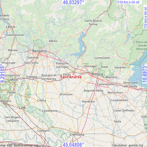
Sant'Andrea GPS coordinates[2]
45° 32' 33.612" North, 9° 59' 39.012" East
| Map corner | latitude | longitude |
|---|---|---|
| Upper-left | 46.03297°, | 9.29105° |
| Center: | 45.54267°, | 9.99417° |
| Lower-right: | 45.04806°, | 10.6973° |
| Map W x H: | 109.5×109.5 km | = 68×68mi |
| max Lat: | 47.04031° ⇑24.9% North |
| Sant'Andrea: | 45.54267° |
| min Lat: | ⇓75.1% South 35.50142° |
| min Long | Sant'Andrea | max Long |
| 6.69888° | 9.99417° | 18.48682° |
| W 32.1%⇐ | ⇒67.9% E |
Elevation
Elevation of Sant'Andrea is 150 m = 492 ft, and this is 156.7 m = 514 ft below average elevation for this country.
| Max E: |
2085 m = 6841 ft | 61.8% |
| Avg. | 306.7 m = 1006 ft | |
| Sant'Andrea | 150 m = 492 ft | |
Min E: |
-4 m = -13 ft | 38.2% |
See also: Italy elevation on elevation.city.
Geographical zone
Sant'Andrea is located in North temperate zone (between Tropic of Cancer and the Arctic Circle). Distance of this North polar circle is 2337.3 km =1452.3 mi to North.| Distance of | km | miles | from Sant'Andrea |
|---|---|---|---|
| North Pole | 4943.2 | 3071.6 | to North |
| Arctic Circle | 2337.3 | 1452.3 | to North |
| Tropic Cancer | 2458 | 1527.3 | to South |
| Equator | 5063.9 | 3146.6 | to South |


Nearby cities:
15 places around Sant'Andrea: (largest is in red/bold)
• Berlinghetto
5.1 km =3.2 mi,  134°
134°
• Berlingo
5.4 km =3.4 mi,  144°
144°
• Castelcovati
5.9 km =3.7 mi,  219°
219°
• Castrezzato
3.6 km =2.2 mi,  196°
196°
• Cazzago San Martino-Calino
5.2 km =3.2 mi,  26°
26°
• Chiari
5.3 km =3.3 mi,  263°
263°
• Coccaglio
2.9 km =1.8 mi,  324°
324°
• Cologne
5.7 km =3.5 mi,  314°
314°
• Costa-Barco
5.7 km =3.5 mi,  37°
37°
• Duomo
2.4 km =1.5 mi,  118°
118°
• Lodetto
3.1 km =1.9 mi,  72°
72°
• Ospitaletto
6.4 km =4 mi,  80°
80°
• Rovato
2.4 km =1.5 mi,  15°
15°
• Segabiello
4 km =2.5 mi,  89°
89°
• Villa Pedergnano
4.7 km =2.9 mi,  359°
359°
Sources, notices
• [Note1] Compared only with cities in Italy existing in our database
• [Src1] Map data: © OpenStreetMap contributors (CC-BY-SA)
• [Src2] Other city data from geonames.org with taken over terms of usage.
• [Src3] Geographical zone / Annual Mean Temperature by Robert A. Rohde @ Wikipedia
