Chiari geodata
Chiari (Lombardy) is a seat of a third-order administrative division; located in Italy in Europe/Rome (GMT+2) time zone. With population of 15,541 people, there are 586 cities with bigger population in this country. Compared to other cities in Italy, 74.9% of cities are located further ↓South; 68.6% of cities are located further →East and 61.8% of cities have higher elevation than Chiari. Note1


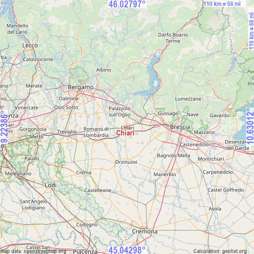
Chiari GPS coordinates[2]
45° 32' 15.468" North, 9° 55' 37.164" East
| Map corner | latitude | longitude |
|---|---|---|
| Upper-left | 46.02797°, | 9.22386° |
| Center: | 45.53763°, | 9.92699° |
| Lower-right: | 45.04298°, | 10.63012° |
| Map W x H: | 109.5×109.5 km | = 68×68mi |
| max Lat: | 47.04031° ⇑25.1% North |
| Chiari: | 45.53763° |
| min Lat: | ⇓74.9% South 35.50142° |
| min Long | Chiari | max Long |
| 6.69888° | 9.92699° | 18.48682° |
| W 31.4%⇐ | ⇒68.6% E |
Elevation
Elevation of Chiari is 150 m = 492 ft, and this is 156.7 m = 514 ft below average elevation for this country.
| Max E: |
2085 m = 6841 ft | 61.8% |
| Avg. | 306.7 m = 1006 ft | |
| Chiari | 150 m = 492 ft | |
Min E: |
-4 m = -13 ft | 38.2% |
See also: Italy elevation on elevation.city.
Geographical zone
Chiari is located in North temperate zone (between Tropic of Cancer and the Arctic Circle). Distance of this North polar circle is 2337.9 km =1452.7 mi to North.| Distance of | km | miles | from Chiari |
|---|---|---|---|
| North Pole | 4943.8 | 3071.9 | to North |
| Arctic Circle | 2337.9 | 1452.7 | to North |
| Tropic Cancer | 2457.4 | 1527 | to South |
| Equator | 5063.3 | 3146.2 | to South |


Nearby cities:
15 places around Chiari: (largest is in red/bold)
• Calcio
6.9 km =4.3 mi,  241°
241°
• Castelcovati
4.2 km =2.6 mi,  159°
159°
• Castrezzato
5.1 km =3.2 mi,  124°
124°
• Cizzago
7.6 km =4.7 mi,  166°
166°
• Coccaglio
4.6 km =2.9 mi,  50°
50°
• Cologne
4.7 km =2.9 mi,  14°
14°
• Duomo
7.4 km =4.6 mi,  94°
94°
• Erbusco
7.6 km =4.7 mi,  27°
27°
• Palazzolo sull'Oglio
7.3 km =4.5 mi,  334°
334°
• Pontoglio
6.7 km =4.2 mi,  301°
301°
• Rovato
6.5 km =4 mi,  63°
63°
• Rudiano
6.2 km =3.9 mi,  210°
210°
• Sant'Andrea
5.3 km =3.3 mi,  83°
83°
• Urago d'Oglio
5.1 km =3.2 mi, 241°
• Villa Pedergnano
7.4 km =4.6 mi,  44°
44°
Sources, notices
• [Note1] Compared only with cities in Italy existing in our database
• [Src1] Map data: © OpenStreetMap contributors (CC-BY-SA)
• [Src2] Other city data from geonames.org with taken over terms of usage.
• [Src3] Geographical zone / Annual Mean Temperature by Robert A. Rohde @ Wikipedia
