Berlinghetto geodata
Berlinghetto (Lombardy) is a populated place; located in Italy in Europe/Rome (GMT+2) time zone. With population of 885 people, there are 7236 cities with bigger population in this country. Compared to other cities in Italy, 74% of cities are located further ↓South; 67.4% of cities are located further →East and 65.3% of cities have higher elevation than Berlinghetto. Note1


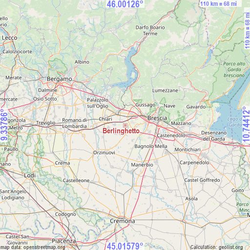
Berlinghetto GPS coordinates[2]
45° 30' 38.448" North, 10° 2' 27.564" East
| Map corner | latitude | longitude |
|---|---|---|
| Upper-left | 46.00126°, | 9.33786° |
| Center: | 45.51068°, | 10.04099° |
| Lower-right: | 45.01579°, | 10.74412° |
| Map W x H: | 109.6×109.6 km | = 68.1×68.1mi |
| max Lat: | 47.04031° ⇑26% North |
| Berlinghetto: | 45.51068° |
| min Lat: | ⇓74% South 35.50142° |
| min Long | Berlinghetto | max Long |
| 6.69888° | 10.04099° | 18.48682° |
| W 32.6%⇐ | ⇒67.4% E |
Elevation
Elevation of Berlinghetto is 126 m = 413 ft, and this is 180.7 m = 593 ft below average elevation for this country.
| Max E: |
2085 m = 6841 ft | 65.3% |
| Avg. | 306.7 m = 1006 ft | |
| Berlinghetto | 126 m = 413 ft | |
Min E: |
-4 m = -13 ft | 34.7% |
See also: Italy elevation on elevation.city.
Geographical zone
Berlinghetto is located in North temperate zone (between Tropic of Cancer and the Arctic Circle). Distance of this North polar circle is 2340.9 km =1454.6 mi to North.| Distance of | km | miles | from Berlinghetto |
|---|---|---|---|
| North Pole | 4946.7 | 3073.7 | to North |
| Arctic Circle | 2340.9 | 1454.6 | to North |
| Tropic Cancer | 2454.4 | 1525.1 | to South |
| Equator | 5060.3 | 3144.3 | to South |


Nearby cities:
15 places around Berlinghetto: (largest is in red/bold)
• Berlingo
1 km =0.6 mi,  210°
210°
• Brandico
6.3 km =3.9 mi,  171°
171°
• Castrezzato
4.7 km =2.9 mi,  270°
270°
• Duomo
2.9 km =1.8 mi,  327°
327°
• Lodetto
4.5 km =2.8 mi,  350°
350°
• Lograto
3.1 km =1.9 mi,  157°
157°
• Maclodio
3.7 km =2.3 mi,  178°
178°
• Ospitaletto
5.3 km =3.3 mi,  30°
30°
• Pievedizio
6.7 km =4.2 mi,  146°
146°
• Rovato
6.6 km =4.1 mi, 332°
• Sant'Andrea
5.1 km =3.2 mi,  314°
314°
• Segabiello
3.6 km =2.2 mi,  6°
6°
• Torbole Casaglia
5.9 km =3.7 mi,  87°
87°
• Travagliato
3.4 km =2.1 mi,  64°
64°
• Trenzano
4.4 km =2.7 mi, 212°
Sources, notices
• [Note1] Compared only with cities in Italy existing in our database
• [Src1] Map data: © OpenStreetMap contributors (CC-BY-SA)
• [Src2] Other city data from geonames.org with taken over terms of usage.
• [Src3] Geographical zone / Annual Mean Temperature by Robert A. Rohde @ Wikipedia
