Santa Margherita geodata
Santa Margherita (Lombardy) is a populated place; located in Italy in Europe/Rome (GMT+2) time zone. With population of 4,862 people, there are 2011 cities with bigger population in this country. Compared to other cities in Italy, 78.4% of cities are located further ↓South; 77.6% of cities are located further →East and 54.2% of cities have higher elevation than Santa Margherita. Note1
Administrative division(s):
- Level 1: Lombardy
- Level 2: Provincia di Monza e della Brianza
- Level 3: Lissone


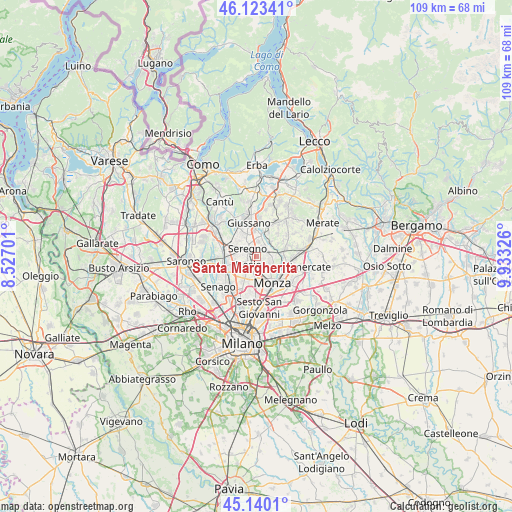
Santa Margherita GPS coordinates[2]
45° 38' 2.076" North, 9° 13' 48.468" East
| Map corner | latitude | longitude |
|---|---|---|
| Upper-left | 46.12341°, | 8.52701° |
| Center: | 45.63391°, | 9.23013° |
| Lower-right: | 45.1401°, | 9.93326° |
| Map W x H: | 109.3×109.3 km | = 67.9×67.9mi |
| max Lat: | 47.04031° ⇑21.6% North |
| Santa Margherita: | 45.63391° |
| min Lat: | ⇓78.4% South 35.50142° |
| min Long | Santa Margherit | max Long |
| 6.69888° | 9.23013° | 18.48682° |
| W 22.4%⇐ | ⇒77.6% E |
Elevation
Elevation of Santa Margherita is 208 m = 682 ft, and this is 98.7 m = 324 ft below average elevation for this country.
| Max E: |
2085 m = 6841 ft | 54.2% |
| Avg. | 306.7 m = 1006 ft | |
| Santa Margherita | 208 m = 682 ft | |
Min E: |
-4 m = -13 ft | 45.8% |
See also: Italy elevation on elevation.city.
Geographical zone
Santa Margherita is located in North temperate zone (between Tropic of Cancer and the Arctic Circle). Distance of this North polar circle is 2327.2 km =1446.1 mi to North.| Distance of | km | miles | from Santa Margherita |
|---|---|---|---|
| North Pole | 4933 | 3065.2 | to North |
| Arctic Circle | 2327.2 | 1446.1 | to North |
| Tropic Cancer | 2468.1 | 1533.6 | to South |
| Equator | 5074 | 3152.8 | to South |


Nearby cities:
15 places around Santa Margherita: (largest is in red/bold)
• Agliate
5.8 km =3.6 mi,  6°
6°
• Albiate
2.9 km =1.8 mi,  33°
33°
• Biassono
3.2 km =2 mi,  100°
100°
• Calò
5.6 km =3.5 mi, 27°
• Canonica
5.1 km =3.2 mi,  61°
61°
• Carate Brianza
4.7 km =2.9 mi, 6°
• Desio
2.8 km =1.7 mi,  231°
231°
• Lissone
2.5 km =1.6 mi,  162°
162°
• Macherio
3.5 km =2.2 mi,  79°
79°
• Muggiò
5 km =3.1 mi,  182°
182°
• Nova Milanese
5.6 km =3.5 mi,  206°
206°
• Seregno
2.6 km =1.6 mi,  313°
313°
• Sovico
2.9 km =1.8 mi, 62°
• Triuggio
4.2 km =2.6 mi,  43°
43°
• Vedano al Lambro
4.1 km =2.5 mi,  133°
133°
Sources, notices
• [Note1] Compared only with cities in Italy existing in our database
• [Src1] Map data: © OpenStreetMap contributors (CC-BY-SA)
• [Src2] Other city data from geonames.org with taken over terms of usage.
• [Src3] Geographical zone / Annual Mean Temperature by Robert A. Rohde @ Wikipedia
