Longhena geodata
Longhena (Lombardy) is a seat of a third-order administrative division; located in Italy in Europe/Rome (GMT+2) time zone. With population of 586 people, there are 9123 cities with bigger population in this country. Compared to other cities in Italy, 71.5% of cities are located further ↓South; 67.2% of cities are located further →East and 70.9% of cities have higher elevation than Longhena. Note1


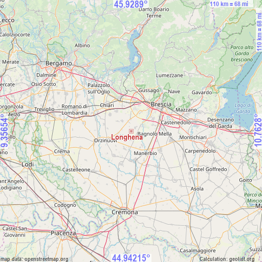
Longhena GPS coordinates[2]
45° 26' 15.648" North, 10° 3' 34.812" East
| Map corner | latitude | longitude |
|---|---|---|
| Upper-left | 45.9289°, | 9.35654° |
| Center: | 45.43768°, | 10.05967° |
| Lower-right: | 44.94215°, | 10.7628° |
| Map W x H: | 109.7×109.7 km | = 68.2×68.2mi |
| max Lat: | 47.04031° ⇑28.5% North |
| Longhena: | 45.43768° |
| min Lat: | ⇓71.5% South 35.50142° |
| min Long | Longhena | max Long |
| 6.69888° | 10.05967° | 18.48682° |
| W 32.8%⇐ | ⇒67.2% E |
Elevation
Elevation of Longhena is 93 m = 305 ft, and this is 213.7 m = 701 ft below average elevation for this country.
| Max E: |
2085 m = 6841 ft | 70.9% |
| Avg. | 306.7 m = 1006 ft | |
| Longhena | 93 m = 305 ft | |
Min E: |
-4 m = -13 ft | 29.1% |
See also: Italy elevation on elevation.city.
Geographical zone
Longhena is located in North temperate zone (between Tropic of Cancer and the Arctic Circle). Distance of this North polar circle is 2349 km =1459.6 mi to North.| Distance of | km | miles | from Longhena |
|---|---|---|---|
| North Pole | 4954.9 | 3078.8 | to North |
| Arctic Circle | 2349 | 1459.6 | to North |
| Tropic Cancer | 2446.3 | 1520.1 | to South |
| Equator | 5052.2 | 3139.3 | to South |


Nearby cities:
15 places around Longhena: (largest is in red/bold)
• Azzano Mella
4.9 km =3 mi,  67°
67°
• Barbariga
3.6 km =2.2 mi,  186°
186°
• Bargnano
1.8 km =1.1 mi,  245°
245°
• Brandico
1.9 km =1.2 mi,  343°
343°
• Corticelle Pieve
5 km =3.1 mi,  108°
108°
• Corzano
4.1 km =2.5 mi,  279°
279°
• Dello
2.4 km =1.5 mi,  147°
147°
• Lograto
5.2 km =3.2 mi,  357°
357°
• Maclodio
4.7 km =2.9 mi, 342°
• Mairano
1.9 km =1.2 mi,  53°
53°
• Pievedizio
3.4 km =2.1 mi,  40°
40°
• Pompiano
5.6 km =3.5 mi,  262°
262°
• Quinzanello
3.6 km =2.2 mi,  124°
124°
• Scarpizzolo
6.7 km =4.2 mi, 186°
• Trenzano
5.8 km =3.6 mi,  319°
319°
Sources, notices
• [Note1] Compared only with cities in Italy existing in our database
• [Src1] Map data: © OpenStreetMap contributors (CC-BY-SA)
• [Src2] Other city data from geonames.org with taken over terms of usage.
• [Src3] Geographical zone / Annual Mean Temperature by Robert A. Rohde @ Wikipedia
