Roncadelle geodata
Roncadelle (Lombardy) is a seat of a third-order administrative division; located in Italy in Europe/Rome (GMT+2) time zone. With population of 8,892 people, there are 1071 cities with bigger population in this country. Compared to other cities in Italy, 74.6% of cities are located further ↓South; 66.4% of cities are located further →East and 66.2% of cities have higher elevation than Roncadelle. Note1


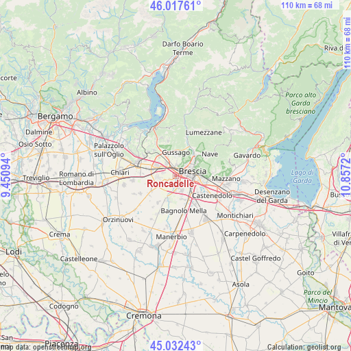
Roncadelle GPS coordinates[2]
45° 31' 37.848" North, 10° 9' 14.652" East
| Map corner | latitude | longitude |
|---|---|---|
| Upper-left | 46.01761°, | 9.45094° |
| Center: | 45.52718°, | 10.15407° |
| Lower-right: | 45.03243°, | 10.8572° |
| Map W x H: | 109.5×109.5 km | = 68×68mi |
| max Lat: | 47.04031° ⇑25.4% North |
| Roncadelle: | 45.52718° |
| min Lat: | ⇓74.6% South 35.50142° |
| min Long | Roncadelle | max Long |
| 6.69888° | 10.15407° | 18.48682° |
| W 33.6%⇐ | ⇒66.4% E |
Elevation
Elevation of Roncadelle is 120 m = 394 ft, and this is 186.7 m = 613 ft below average elevation for this country.
| Max E: |
2085 m = 6841 ft | 66.2% |
| Avg. | 306.7 m = 1006 ft | |
| Roncadelle | 120 m = 394 ft | |
Min E: |
-4 m = -13 ft | 33.8% |
See also: Italy elevation on elevation.city.
Geographical zone
Roncadelle is located in North temperate zone (between Tropic of Cancer and the Arctic Circle). Distance of this North polar circle is 2339 km =1453.4 mi to North.| Distance of | km | miles | from Roncadelle |
|---|---|---|---|
| North Pole | 4944.9 | 3072.6 | to North |
| Arctic Circle | 2339 | 1453.4 | to North |
| Tropic Cancer | 2456.2 | 1526.2 | to South |
| Equator | 5062.1 | 3145.4 | to South |


Nearby cities:
15 places around Roncadelle: (largest is in red/bold)
• Brescia
4.8 km =3 mi,  78°
78°
• Capriano del Colle
6.1 km =3.8 mi,  196°
196°
• Castegnato
4.9 km =3 mi,  320°
320°
• Castel Mella
3.2 km =2 mi,  192°
192°
• Cellatica
6.4 km =4 mi,  18°
18°
• Fantasina
5.4 km =3.4 mi, 19°
• Flero
5.3 km =3.3 mi,  160°
160°
• Folzano
5.4 km =3.4 mi,  130°
130°
• Gussago
6.3 km =3.9 mi,  2°
2°
• Ospitaletto
6.7 km =4.2 mi,  294°
294°
• Piazza
6.7 km =4.2 mi, 0°
• San Zeno Naviglio
6.3 km =3.9 mi, 127°
• Torbole Casaglia
3.3 km =2.1 mi,  241°
241°
• Travagliato
5.8 km =3.6 mi,  266°
266°
• Zerbino
3.8 km =2.4 mi,  166°
166°
Sources, notices
• [Note1] Compared only with cities in Italy existing in our database
• [Src1] Map data: © OpenStreetMap contributors (CC-BY-SA)
• [Src2] Other city data from geonames.org with taken over terms of usage.
• [Src3] Geographical zone / Annual Mean Temperature by Robert A. Rohde @ Wikipedia
