Travagliato geodata
Travagliato (Lombardy) is a seat of a third-order administrative division; located in Italy in Europe/Rome (GMT+2) time zone. With population of 12,828 people, there are 717 cities with bigger population in this country. Compared to other cities in Italy, 74.5% of cities are located further ↓South; 67.1% of cities are located further →East and 64.7% of cities have higher elevation than Travagliato. Note1


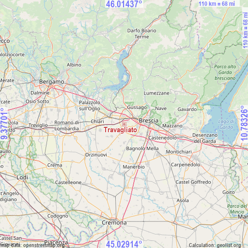
Travagliato GPS coordinates[2]
45° 31' 26.076" North, 10° 4' 48.468" East
| Map corner | latitude | longitude |
|---|---|---|
| Upper-left | 46.01437°, | 9.37701° |
| Center: | 45.52391°, | 10.08013° |
| Lower-right: | 45.02914°, | 10.78326° |
| Map W x H: | 109.5×109.5 km | = 68×68mi |
| max Lat: | 47.04031° ⇑25.5% North |
| Travagliato: | 45.52391° |
| min Lat: | ⇓74.5% South 35.50142° |
| min Long | Travagliato | max Long |
| 6.69888° | 10.08013° | 18.48682° |
| W 32.9%⇐ | ⇒67.1% E |
Elevation
Elevation of Travagliato is 129 m = 423 ft, and this is 177.7 m = 583 ft below average elevation for this country.
| Max E: |
2085 m = 6841 ft | 64.7% |
| Avg. | 306.7 m = 1006 ft | |
| Travagliato | 129 m = 423 ft | |
Min E: |
-4 m = -13 ft | 35.3% |
See also: Italy elevation on elevation.city.
Geographical zone
Travagliato is located in North temperate zone (between Tropic of Cancer and the Arctic Circle). Distance of this North polar circle is 2339.4 km =1453.6 mi to North.| Distance of | km | miles | from Travagliato |
|---|---|---|---|
| North Pole | 4945.3 | 3072.9 | to North |
| Arctic Circle | 2339.4 | 1453.6 | to North |
| Tropic Cancer | 2455.9 | 1526 | to South |
| Equator | 5061.8 | 3145.3 | to South |


Nearby cities:
15 places around Travagliato: (largest is in red/bold)
• Berlinghetto
3.4 km =2.1 mi,  244°
244°
• Berlingo
4.3 km =2.7 mi, 236°
• Capriano del Colle
6.8 km =4.2 mi,  143°
143°
• Castegnato
4.9 km =3 mi,  32°
32°
• Castel Mella
5.8 km =3.6 mi,  118°
118°
• Duomo
4.7 km =2.9 mi,  281°
281°
• Lodetto
4.8 km =3 mi,  308°
308°
• Lograto
4.7 km =2.9 mi,  202°
202°
• Maclodio
5.9 km =3.7 mi,  209°
209°
• Ospitaletto
3.2 km =2 mi,  353°
353°
• Paderno Franciacorta
7 km =4.3 mi,  359°
359°
• Roncadelle
5.8 km =3.6 mi,  86°
86°
• Sant'Andrea
7 km =4.3 mi,  287°
287°
• Segabiello
3.4 km =2.1 mi, 308°
• Torbole Casaglia
3.1 km =1.9 mi,  113°
113°
Sources, notices
• [Note1] Compared only with cities in Italy existing in our database
• [Src1] Map data: © OpenStreetMap contributors (CC-BY-SA)
• [Src2] Other city data from geonames.org with taken over terms of usage.
• [Src3] Geographical zone / Annual Mean Temperature by Robert A. Rohde @ Wikipedia
