Gombito geodata
Gombito (Lombardy) is a seat of a third-order administrative division; located in Italy in Europe/Rome (GMT+2) time zone. With population of 578 people, there are 9196 cities with bigger population in this country. Compared to other cities in Italy, 66.5% of cities are located further ↓South; 70.5% of cities are located further →East and 78.8% of cities have higher elevation than Gombito. Note1


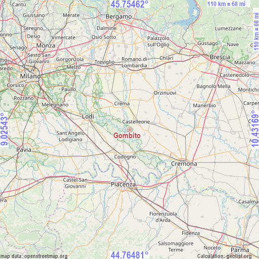
Gombito GPS coordinates[2]
45° 15' 42.732" North, 9° 43' 42.816" East
| Map corner | latitude | longitude |
|---|---|---|
| Upper-left | 45.75462°, | 9.02543° |
| Center: | 45.26187°, | 9.72856° |
| Lower-right: | 44.76481°, | 10.43169° |
| Map W x H: | 110.1×110.1 km | = 68.4×68.4mi |
| max Lat: | 47.04031° ⇑33.5% North |
| Gombito: | 45.26187° |
| min Lat: | ⇓66.5% South 35.50142° |
| min Long | Gombito | max Long |
| 6.69888° | 9.72856° | 18.48682° |
| W 29.5%⇐ | ⇒70.5% E |
Elevation
Elevation of Gombito is 55 m = 180 ft, and this is 251.7 m = 826 ft below average elevation for this country.
| Max E: |
2085 m = 6841 ft | 78.8% |
| Avg. | 306.7 m = 1006 ft | |
| Gombito | 55 m = 180 ft | |
Min E: |
-4 m = -13 ft | 21.2% |
See also: Italy elevation on elevation.city.
Geographical zone
Gombito is located in North temperate zone (between Tropic of Cancer and the Arctic Circle). Distance of this North polar circle is 2368.5 km =1471.7 mi to North.| Distance of | km | miles | from Gombito |
|---|---|---|---|
| North Pole | 4974.4 | 3090.9 | to North |
| Arctic Circle | 2368.5 | 1471.7 | to North |
| Tropic Cancer | 2426.7 | 1507.9 | to South |
| Equator | 5032.6 | 3127.1 | to South |


Nearby cities:
15 places around Gombito: (largest is in red/bold)
• Bertonico
5.7 km =3.5 mi,  235°
235°
• Camairago
6.3 km =3.9 mi,  180°
180°
• Castelleone
4.5 km =2.8 mi,  33°
33°
• Castiglione d'Adda
5.7 km =3.5 mi,  209°
209°
• Cavacurta
8.1 km =5 mi,  172°
172°
• Credera
7.4 km =4.6 mi,  308°
308°
• Formigara
5.4 km =3.4 mi,  142°
142°
• Fornaci
8.1 km =5 mi, 209°
• Montodine
2.9 km =1.8 mi,  328°
328°
• Moscazzano
5.1 km =3.2 mi, 313°
• Ripalta Arpina
4.4 km =2.7 mi,  0°
0°
• Ripalta Guerina
5.3 km =3.3 mi,  338°
338°
• Ripalta Nuova
8.3 km =5.2 mi, 340°
• San Bassano
6.7 km =4.2 mi,  107°
107°
• Terranova dei Passerini
7.4 km =4.6 mi,  225°
225°
Sources, notices
• [Note1] Compared only with cities in Italy existing in our database
• [Src1] Map data: © OpenStreetMap contributors (CC-BY-SA)
• [Src2] Other city data from geonames.org with taken over terms of usage.
• [Src3] Geographical zone / Annual Mean Temperature by Robert A. Rohde @ Wikipedia
