Formigara geodata
Formigara (Lombardy) is a seat of a third-order administrative division; located in Italy in Europe/Rome (GMT+2) time zone. With population of 750 people, there are 7955 cities with bigger population in this country. Compared to other cities in Italy, 65.5% of cities are located further ↓South; 70% of cities are located further →East and 77.7% of cities have higher elevation than Formigara. Note1


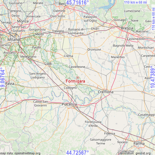
Formigara GPS coordinates[2]
45° 13' 23.052" North, 9° 46' 14.736" East
| Map corner | latitude | longitude |
|---|---|---|
| Upper-left | 45.71616°, | 9.06764° |
| Center: | 45.22307°, | 9.77076° |
| Lower-right: | 44.72567°, | 10.47389° |
| Map W x H: | 110.1×110.1 km | = 68.4×68.4mi |
| max Lat: | 47.04031° ⇑34.5% North |
| Formigara: | 45.22307° |
| min Lat: | ⇓65.5% South 35.50142° |
| min Long | Formigara | max Long |
| 6.69888° | 9.77076° | 18.48682° |
| W 30%⇐ | ⇒70% E |
Elevation
Elevation of Formigara is 61 m = 200 ft, and this is 245.7 m = 806 ft below average elevation for this country.
| Max E: |
2085 m = 6841 ft | 77.7% |
| Avg. | 306.7 m = 1006 ft | |
| Formigara | 61 m = 200 ft | |
Min E: |
-4 m = -13 ft | 22.3% |
See also: Italy elevation on elevation.city.
Geographical zone
Formigara is located in North temperate zone (between Tropic of Cancer and the Arctic Circle). Distance of this North polar circle is 2372.8 km =1474.4 mi to North.| Distance of | km | miles | from Formigara |
|---|---|---|---|
| North Pole | 4978.7 | 3093.6 | to North |
| Arctic Circle | 2372.8 | 1474.4 | to North |
| Tropic Cancer | 2422.4 | 1505.2 | to South |
| Equator | 5028.3 | 3124.4 | to South |


Nearby cities:
15 places around Formigara: (largest is in red/bold)
• Bertonico
8.1 km =5 mi,  277°
277°
• Camairago
3.9 km =2.4 mi,  239°
239°
• Cappella Cantone
5.9 km =3.7 mi,  63°
63°
• Castelleone
8.1 km =5 mi,  354°
354°
• Castiglione d'Adda
6.1 km =3.8 mi,  263°
263°
• Cavacurta
4.3 km =2.7 mi,  211°
211°
• Fornaci
7.8 km =4.8 mi,  249°
249°
• Gombito
5.4 km =3.4 mi,  322°
322°
• Grumello Cremonese
8 km =5 mi,  113°
113°
• Maleo
6.3 km =3.9 mi,  185°
185°
• Pizzighettone
4.2 km =2.6 mi,  161°
161°
• Regona
4.3 km =2.7 mi,  117°
117°
• Roggione
5.2 km =3.2 mi,  146°
146°
• San Bassano
3.8 km =2.4 mi,  52°
52°
• Santa Maria dei Sabbioni
5.8 km =3.6 mi,  66°
66°
Sources, notices
• [Note1] Compared only with cities in Italy existing in our database
• [Src1] Map data: © OpenStreetMap contributors (CC-BY-SA)
• [Src2] Other city data from geonames.org with taken over terms of usage.
• [Src3] Geographical zone / Annual Mean Temperature by Robert A. Rohde @ Wikipedia
