Baraccone geodata
Baraccone (Piedmont) is a populated place; located in Italy in Europe/Rome (GMT+2) time zone. With population of 778 people, there are 7773 cities with bigger population in this country. Compared to other cities in Italy, 55.2% of cities are located further ↓South; 92.8% of cities are located further →East and 61.2% of cities have higher elevation than Baraccone. Note1


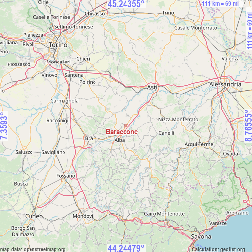
Baraccone GPS coordinates[2]
44° 44' 46.788" North, 8° 3' 44.712" East
| Map corner | latitude | longitude |
|---|---|---|
| Upper-left | 45.24355°, | 7.3593° |
| Center: | 44.74633°, | 8.06242° |
| Lower-right: | 44.24479°, | 8.76555° |
| Map W x H: | 111.1×111.1 km | = 69×69mi |
| max Lat: | 47.04031° ⇑44.8% North |
| Baraccone: | 44.74633° |
| min Lat: | ⇓55.2% South 35.50142° |
| min Long | Baraccone | max Long |
| 6.69888° | 8.06242° | 18.48682° |
| W 7.2%⇐ | ⇒92.8% E |
Elevation
Elevation of Baraccone is 154 m = 505 ft, and this is 152.7 m = 501 ft below average elevation for this country.
| Max E: |
2085 m = 6841 ft | 61.2% |
| Avg. | 306.7 m = 1006 ft | |
| Baraccone | 154 m = 505 ft | |
Min E: |
-4 m = -13 ft | 38.8% |
See also: Italy elevation on elevation.city.
Geographical zone
Baraccone is located in North temperate zone (between Tropic of Cancer and the Arctic Circle). Distance of this Northern Tropic circle is 2369.4 km =1472.3 mi to South.| Distance of | km | miles | from Baraccone |
|---|---|---|---|
| North Pole | 5031.7 | 3126.6 | to North |
| Arctic Circle | 2425.8 | 1507.3 | to North |
| Tropic Cancer | 2369.4 | 1472.3 | to South |
| Equator | 4975.3 | 3091.5 | to South |


Nearby cities:
15 places around Baraccone: (largest is in red/bold)
• Alba
5.6 km =3.5 mi,  202°
202°
• Barbaresco
3 km =1.9 mi,  149°
149°
• Canove
4.2 km =2.6 mi,  34°
34°
• Castagnito
2.6 km =1.6 mi,  291°
291°
• Castellinaldo
4.1 km =2.5 mi,  320°
320°
• Castelrotto
4.6 km =2.9 mi,  243°
243°
• Guarene
2.3 km =1.4 mi,  252°
252°
• Magliano Alfieri
2.6 km =1.6 mi,  13°
13°
• Mussotto
3.9 km =2.4 mi,  215°
215°
• Neive-Borgonovo
5 km =3.1 mi,  119°
119°
• Priocca
4.4 km =2.7 mi,  1°
1°
• San Giuseppe
1 km =0.6 mi,  305°
305°
• Sant'Antonio
1.5 km =0.9 mi,  23°
23°
• Vaccheria
2.6 km =1.6 mi, 215°
• Vezza d'Alba
4.7 km =2.9 mi, 292°
Sources, notices
• [Note1] Compared only with cities in Italy existing in our database
• [Src1] Map data: © OpenStreetMap contributors (CC-BY-SA)
• [Src2] Other city data from geonames.org with taken over terms of usage.
• [Src3] Geographical zone / Annual Mean Temperature by Robert A. Rohde @ Wikipedia
