Vottignasco geodata
Vottignasco (Piedmont) is a seat of a third-order administrative division; located in Italy in Europe/Rome (GMT+2) time zone. With population of 267 people, there are 10817 cities with bigger population in this country. Compared to other cities in Italy, 51.9% of cities are located further ↓South; 97.2% of cities are located further →East and 69.4% of cities have lower elevation than Vottignasco. Note1


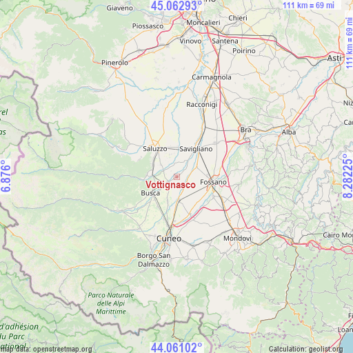
Vottignasco GPS coordinates[2]
44° 33' 50.868" North, 7° 34' 44.868" East
| Map corner | latitude | longitude |
|---|---|---|
| Upper-left | 45.06293°, | 6.876° |
| Center: | 44.56413°, | 7.57913° |
| Lower-right: | 44.06102°, | 8.28225° |
| Map W x H: | 111.4×111.4 km | = 69.2×69.2mi |
| max Lat: | 47.04031° ⇑48.1% North |
| Vottignasco: | 44.56413° |
| min Lat: | ⇓51.9% South 35.50142° |
| min Long | Vottignasco | max Long |
| 6.69888° | 7.57913° | 18.48682° |
| W 2.8%⇐ | ⇒97.2% E |
Elevation
Elevation of Vottignasco is 388 m = 1273 ft, and this is 81.3 m = 267 ft above average elevation for this country.
| Max E: |
2085 m = 6841 ft | 30.6% |
| Vottignasco | 388 m 1273 ft | |
| Avg. | 306.7 m = 1006 ft | |
Min E: |
-4 m = -13 ft | 69.4% |
See also: Italy elevation on elevation.city.
Geographical zone
Vottignasco is located in North temperate zone (between Tropic of Cancer and the Arctic Circle). Distance of this Northern Tropic circle is 2349.1 km =1459.7 mi to South.| Distance of | km | miles | from Vottignasco |
|---|---|---|---|
| North Pole | 5052 | 3139.2 | to North |
| Arctic Circle | 2446.1 | 1519.9 | to North |
| Tropic Cancer | 2349.1 | 1459.7 | to South |
| Equator | 4955.1 | 3079 | to South |


Nearby cities:
15 places around Vottignasco: (largest is in red/bold)
• Busca
9.7 km =6 mi,  236°
236°
• Centallo
7 km =4.3 mi,  174°
174°
• Costiglione Saluzzo
7.4 km =4.6 mi,  270°
270°
• Fossano
11.2 km =7 mi,  97°
97°
• Genola
7.1 km =4.4 mi,  65°
65°
• Lagnasco
7 km =4.3 mi,  344°
344°
• Levaldigi
3.5 km =2.2 mi, 102°
• Manta
9.3 km =5.8 mi,  308°
308°
• Piasco
10.7 km =6.6 mi, 268°
• San Biagio
9.5 km =5.9 mi,  164°
164°
• San Chiaffredo
11.2 km =7 mi,  213°
213°
• Savigliano
11.2 km =7 mi,  33°
33°
• Tarantasca
8.3 km =5.2 mi,  199°
199°
• Verzuolo
8.4 km =5.2 mi,  292°
292°
• Villafalletto
3.6 km =2.2 mi, 236°
Sources, notices
• [Note1] Compared only with cities in Italy existing in our database
• [Src1] Map data: © OpenStreetMap contributors (CC-BY-SA)
• [Src2] Other city data from geonames.org with taken over terms of usage.
• [Src3] Geographical zone / Annual Mean Temperature by Robert A. Rohde @ Wikipedia
