Centallo geodata
Centallo (Piedmont) is a seat of a third-order administrative division; located in Italy in Europe/Rome (GMT+2) time zone. With population of 3,939 people, there are 2426 cities with bigger population in this country. Compared to other cities in Italy, 51% of cities are located further ↓South; 97.2% of cities are located further →East and 73% of cities have lower elevation than Centallo. Note1


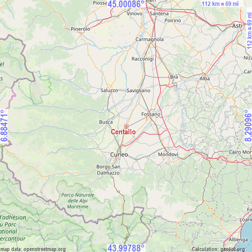
Centallo GPS coordinates[2]
44° 30' 5.508" North, 7° 35' 16.188" East
| Map corner | latitude | longitude |
|---|---|---|
| Upper-left | 45.00086°, | 6.88471° |
| Center: | 44.50153°, | 7.58783° |
| Lower-right: | 43.99788°, | 8.29096° |
| Map W x H: | 111.5×111.5 km | = 69.3×69.3mi |
| max Lat: | 47.04031° ⇑49% North |
| Centallo: | 44.50153° |
| min Lat: | ⇓51% South 35.50142° |
| min Long | Centallo | max Long |
| 6.69888° | 7.58783° | 18.48682° |
| W 2.8%⇐ | ⇒97.2% E |
Elevation
Elevation of Centallo is 425 m = 1394 ft, and this is 118.3 m = 388 ft above average elevation for this country.
| Max E: |
2085 m = 6841 ft | 27% |
| Centallo | 425 m 1394 ft | |
| Avg. | 306.7 m = 1006 ft | |
Min E: |
-4 m = -13 ft | 73% |
See also: Italy elevation on elevation.city.
Geographical zone
Centallo is located in North temperate zone (between Tropic of Cancer and the Arctic Circle). Distance of this Northern Tropic circle is 2342.2 km =1455.4 mi to South.| Distance of | km | miles | from Centallo |
|---|---|---|---|
| North Pole | 5059 | 3143.5 | to North |
| Arctic Circle | 2453.1 | 1524.3 | to North |
| Tropic Cancer | 2342.2 | 1455.4 | to South |
| Equator | 4948.1 | 3074.6 | to South |


Nearby cities:
15 places around Centallo: (largest is in red/bold)
• Busca
9 km =5.6 mi,  280°
280°
• Castelletto Stura
7.6 km =4.7 mi,  147°
147°
• Costiglione Saluzzo
10.7 km =6.6 mi,  310°
310°
• Genola
11.5 km =7.1 mi,  30°
30°
• Levaldigi
6.8 km =4.2 mi,  23°
23°
• Montanera
7.6 km =4.7 mi,  125°
125°
• Passatore
10.1 km =6.3 mi,  219°
219°
• Roata Chiusani
4.5 km =2.8 mi,  175°
175°
• Roata Rossi
8.1 km =5 mi, 217°
• San Biagio
2.8 km =1.7 mi,  140°
140°
• San Chiaffredo
7.2 km =4.5 mi,  250°
250°
• Sant'Albano Stura
10.7 km =6.6 mi,  86°
86°
• Tarantasca
3.6 km =2.2 mi, 254°
• Villafalletto
6.2 km =3.9 mi,  323°
323°
• Vottignasco
7 km =4.3 mi,  354°
354°
Sources, notices
• [Note1] Compared only with cities in Italy existing in our database
• [Src1] Map data: © OpenStreetMap contributors (CC-BY-SA)
• [Src2] Other city data from geonames.org with taken over terms of usage.
• [Src3] Geographical zone / Annual Mean Temperature by Robert A. Rohde @ Wikipedia
