Rocca Pietore geodata
Rocca Pietore (Veneto) is a seat of a third-order administrative division; located in Italy in Europe/Rome (GMT+2) time zone. With population of 174 people, there are 11213 cities with bigger population in this country. Compared to other cities in Italy, 98% of cities are located further ↓South; 55.6% of cities are located further ←West and 98.3% of cities have lower elevation than Rocca Pietore. Note1


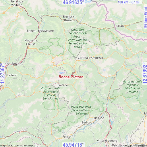
Rocca Pietore GPS coordinates[2]
46° 26' 2.112" North, 11° 58' 36.444" East
| Map corner | latitude | longitude |
|---|---|---|
| Upper-left | 46.91635°, | 11.27367° |
| Center: | 46.43392°, | 11.97679° |
| Lower-right: | 45.94718°, | 12.67992° |
| Map W x H: | 107.8×107.8 km | = 67×67mi |
| max Lat: | 47.04031° ⇑2% North |
| Rocca Pietore: | 46.43392° |
| min Lat: | ⇓98% South 35.50142° |
| min Long | Rocca Pietore | max Long |
| 6.69888° | 11.97679° | 18.48682° |
| W 55.6%⇐ | ⇒44.4% E |
Elevation
Elevation of Rocca Pietore is 1150 m = 3773 ft, and this is 843.3 m = 2767 ft above average elevation for this country.
| Max E: |
2085 m = 6841 ft | 1.7% |
| Rocca Pietore | 1150 m 3773 ft | |
| Avg. | 306.7 m = 1006 ft | |
Min E: |
-4 m = -13 ft | 98.3% |
See also: Italy elevation on elevation.city.
Geographical zone
Rocca Pietore is located in North temperate zone (between Tropic of Cancer and the Arctic Circle). Distance of this North polar circle is 2238.2 km =1390.8 mi to North.| Distance of | km | miles | from Rocca Pietore |
|---|---|---|---|
| North Pole | 4844.1 | 3010 | to North |
| Arctic Circle | 2238.2 | 1390.8 | to North |
| Tropic Cancer | 2557 | 1588.8 | to South |
| Equator | 5163 | 3208.1 | to South |


Nearby cities:
15 places around Rocca Pietore: (largest is in red/bold)
• Alba-Penia
14 km =8.7 mi,  280°
280°
• Alleghe
4.6 km =2.9 mi,  129°
129°
• Canale d'Agordo
9.8 km =6.1 mi,  209°
209°
• Caviola
9.9 km =6.2 mi,  218°
218°
• Celat-San Tomaso Agordino
5.9 km =3.7 mi,  181°
181°
• Cencenighe Agordino
9.2 km =5.7 mi, 184°
• Colle Santa Lucia
3.3 km =2.1 mi,  60°
60°
• Falcade Alto
12.7 km =7.9 mi,  226°
226°
• Fusine
13.1 km =8.1 mi,  119°
119°
• Livinallongo del Col di Lana
5.6 km =3.5 mi,  341°
341°
• Pie' Falcade
11.8 km =7.3 mi, 223°
• Sachet
7.9 km =4.9 mi, 206°
• Selva di Cadore
6.4 km =4 mi,  73°
73°
• Vallada Agordina
8.4 km =5.2 mi,  203°
203°
• Zoldo Alto
13.2 km =8.2 mi, 119°
Sources, notices
• [Note1] Compared only with cities in Italy existing in our database
• [Src1] Map data: © OpenStreetMap contributors (CC-BY-SA)
• [Src2] Other city data from geonames.org with taken over terms of usage.
• [Src3] Geographical zone / Annual Mean Temperature by Robert A. Rohde @ Wikipedia
