Felitto geodata
Felitto (Campania) is a seat of a third-order administrative division; located in Italy in Europe/Rome (GMT+2) time zone. With population of 795 people, there are 7674 cities with bigger population in this country. Compared to other cities in Italy, 85.1% of cities are located further ↑North; 89.2% of cities are located further ←West and 56.6% of cities have lower elevation than Felitto. Note1


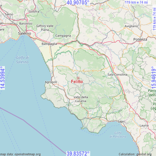
Felitto GPS coordinates[2]
40° 22' 24.636" North, 15° 14' 35.016" East
| Map corner | latitude | longitude |
|---|---|---|
| Upper-left | 40.90705°, | 14.53994° |
| Center: | 40.37351°, | 15.24306° |
| Lower-right: | 39.83572°, | 15.94619° |
| Map W x H: | 119.1×119.1 km | = 74×74mi |
| max Lat: | 47.04031° ⇑85.1% North |
| Felitto: | 40.37351° |
| min Lat: | ⇓14.9% South 35.50142° |
| min Long | Felitto | max Long |
| 6.69888° | 15.24306° | 18.48682° |
| W 89.2%⇐ | ⇒10.8% E |
Elevation
Elevation of Felitto is 276 m = 906 ft, and this is 30.7 m = 101 ft below average elevation for this country.
| Max E: |
2085 m = 6841 ft | 43.4% |
| Avg. | 306.7 m = 1006 ft | |
| Felitto | 276 m = 906 ft | |
Min E: |
-4 m = -13 ft | 56.6% |
See also: Italy elevation on elevation.city.
Geographical zone
Felitto is located in North temperate zone (between Tropic of Cancer and the Arctic Circle). Distance of this Northern Tropic circle is 1883.2 km =1170.2 mi to South.| Distance of | km | miles | from Felitto |
|---|---|---|---|
| North Pole | 5517.9 | 3428.7 | to North |
| Arctic Circle | 2912.1 | 1809.5 | to North |
| Tropic Cancer | 1883.2 | 1170.2 | to South |
| Equator | 4489.1 | 2789.4 | to South |


Nearby cities:
15 places around Felitto: (largest is in red/bold)
• Aquara
7.9 km =4.9 mi,  6°
6°
• Bellosguardo
8 km =5 mi,  47°
47°
• Campora
8.6 km =5.3 mi,  151°
151°
• Castel San Lorenzo
5.4 km =3.4 mi,  343°
343°
• Cicerale
10.2 km =6.3 mi,  251°
251°
• Gioi
9.6 km =6 mi,  192°
192°
• Laurino
8.9 km =5.5 mi,  115°
115°
• Magliano Vetere
3 km =1.9 mi, 190°
• Monteforte Cilento
4.2 km =2.6 mi,  256°
256°
• Orria
10.2 km =6.3 mi,  216°
216°
• Roccadaspide
7.1 km =4.4 mi,  321°
321°
• Roscigno
9.2 km =5.7 mi,  71°
71°
• Stio
7.1 km =4.4 mi,  174°
174°
• Valle dell'Angelo
11.1 km =6.9 mi,  107°
107°
• Villa Littorio
8 km =5 mi,  95°
95°
Sources, notices
• [Note1] Compared only with cities in Italy existing in our database
• [Src1] Map data: © OpenStreetMap contributors (CC-BY-SA)
• [Src2] Other city data from geonames.org with taken over terms of usage.
• [Src3] Geographical zone / Annual Mean Temperature by Robert A. Rohde @ Wikipedia
