Laurino geodata
Laurino (Campania) is a seat of a third-order administrative division; located in Italy in Europe/Rome (GMT+2) time zone. With population of 1,056 people, there are 6453 cities with bigger population in this country. Compared to other cities in Italy, 85.3% of cities are located further ↑North; 89.8% of cities are located further ←West and 78.7% of cities have lower elevation than Laurino. Note1


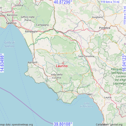
Laurino GPS coordinates[2]
40° 20' 20.94" North, 15° 20' 17.16" East
| Map corner | latitude | longitude |
|---|---|---|
| Upper-left | 40.87296°, | 14.63498° |
| Center: | 40.33915°, | 15.3381° |
| Lower-right: | 39.80108°, | 16.04123° |
| Map W x H: | 119.2×119.2 km | = 74.1×74.1mi |
| max Lat: | 47.04031° ⇑85.3% North |
| Laurino: | 40.33915° |
| min Lat: | ⇓14.7% South 35.50142° |
| min Long | Laurino | max Long |
| 6.69888° | 15.3381° | 18.48682° |
| W 89.8%⇐ | ⇒10.2% E |
Elevation
Elevation of Laurino is 503 m = 1650 ft, and this is 196.3 m = 644 ft above average elevation for this country.
| Max E: |
2085 m = 6841 ft | 21.3% |
| Laurino | 503 m 1650 ft | |
| Avg. | 306.7 m = 1006 ft | |
Min E: |
-4 m = -13 ft | 78.7% |
See also: Italy elevation on elevation.city.
Geographical zone
Laurino is located in North temperate zone (between Tropic of Cancer and the Arctic Circle). Distance of this Northern Tropic circle is 1879.4 km =1167.8 mi to South.| Distance of | km | miles | from Laurino |
|---|---|---|---|
| North Pole | 5521.8 | 3431.1 | to North |
| Arctic Circle | 2915.9 | 1811.9 | to North |
| Tropic Cancer | 1879.4 | 1167.8 | to South |
| Equator | 4485.3 | 2787 | to South |


Nearby cities:
15 places around Laurino: (largest is in red/bold)
• Bellosguardo
9.5 km =5.9 mi,  346°
346°
• Campora
5.4 km =3.4 mi,  225°
225°
• Cannalonga
11.2 km =7 mi,  199°
199°
• Cardile
11.1 km =6.9 mi, 226°
• Corleto Monforte
11.5 km =7.1 mi,  18°
18°
• Felitto
8.9 km =5.5 mi,  295°
295°
• Gioi
11.6 km =7.2 mi,  241°
241°
• Magliano Vetere
8.6 km =5.3 mi,  275°
275°
• Moio della Civitella-Pellare
11.8 km =7.3 mi,  209°
209°
• Piaggine
3.4 km =2.1 mi,  79°
79°
• Roscigno
6.8 km =4.2 mi,  5°
5°
• Sacco
5.4 km =3.4 mi,  38°
38°
• Stio
8 km =5 mi,  246°
246°
• Valle dell'Angelo
2.6 km =1.6 mi, 78°
• Villa Littorio
3 km =1.9 mi,  357°
357°
Sources, notices
• [Note1] Compared only with cities in Italy existing in our database
• [Src1] Map data: © OpenStreetMap contributors (CC-BY-SA)
• [Src2] Other city data from geonames.org with taken over terms of usage.
• [Src3] Geographical zone / Annual Mean Temperature by Robert A. Rohde @ Wikipedia
