Roscigno geodata
Roscigno (Campania) is a seat of a third-order administrative division; located in Italy in Europe/Rome (GMT+2) time zone. With population of 815 people, there are 7569 cities with bigger population in this country. Compared to other cities in Italy, 84.8% of cities are located further ↑North; 89.9% of cities are located further ←West and 83.3% of cities have lower elevation than Roscigno. Note1


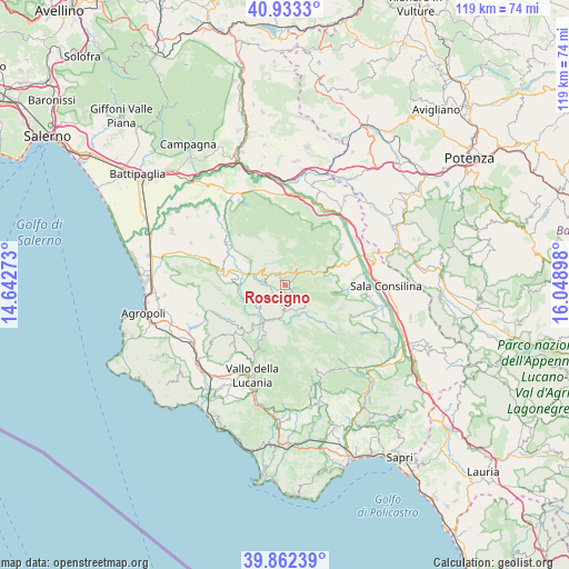
Roscigno GPS coordinates[2]
40° 23' 59.892" North, 15° 20' 45.06" East
| Map corner | latitude | longitude |
|---|---|---|
| Upper-left | 40.9333°, | 14.64273° |
| Center: | 40.39997°, | 15.34585° |
| Lower-right: | 39.86239°, | 16.04898° |
| Map W x H: | 119.1×119.1 km | = 74×74mi |
| max Lat: | 47.04031° ⇑84.8% North |
| Roscigno: | 40.39997° |
| min Lat: | ⇓15.2% South 35.50142° |
| min Long | Roscigno | max Long |
| 6.69888° | 15.34585° | 18.48682° |
| W 89.9%⇐ | ⇒10.1% E |
Elevation
Elevation of Roscigno is 576 m = 1890 ft, and this is 269.3 m = 884 ft above average elevation for this country.
| Max E: |
2085 m = 6841 ft | 16.7% |
| Roscigno | 576 m 1890 ft | |
| Avg. | 306.7 m = 1006 ft | |
Min E: |
-4 m = -13 ft | 83.3% |
See also: Italy elevation on elevation.city.
Geographical zone
Roscigno is located in North temperate zone (between Tropic of Cancer and the Arctic Circle). Distance of this Northern Tropic circle is 1886.1 km =1172 mi to South.| Distance of | km | miles | from Roscigno |
|---|---|---|---|
| North Pole | 5515 | 3426.9 | to North |
| Arctic Circle | 2909.1 | 1807.6 | to North |
| Tropic Cancer | 1886.1 | 1172 | to South |
| Equator | 4492.1 | 2791.3 | to South |


Nearby cities:
15 places around Roscigno: (largest is in red/bold)
• Aquara
9.2 km =5.7 mi,  302°
302°
• Bellosguardo
3.8 km =2.4 mi,  310°
310°
• Campora
11.4 km =7.1 mi,  203°
203°
• Castel San Lorenzo
10.4 km =6.5 mi,  282°
282°
• Corleto Monforte
5.1 km =3.2 mi,  34°
34°
• Felitto
9.2 km =5.7 mi,  251°
251°
• Laurino
6.8 km =4.2 mi,  185°
185°
• Magliano Vetere
11 km =6.8 mi,  237°
237°
• Ottati
7.5 km =4.7 mi,  339°
339°
• Piaggine
6.7 km =4.2 mi,  156°
156°
• Sacco
3.7 km =2.3 mi,  133°
133°
• San Rufo
10.7 km =6.6 mi,  68°
68°
• Sant'Angelo A Fasanella
6.4 km =4 mi,  356°
356°
• Valle dell'Angelo
6.5 km =4 mi, 162°
• Villa Littorio
3.8 km =2.4 mi, 191°
Sources, notices
• [Note1] Compared only with cities in Italy existing in our database
• [Src1] Map data: © OpenStreetMap contributors (CC-BY-SA)
• [Src2] Other city data from geonames.org with taken over terms of usage.
• [Src3] Geographical zone / Annual Mean Temperature by Robert A. Rohde @ Wikipedia
