Premana geodata
Premana (Lombardy) is a seat of a third-order administrative division; located in Italy in Europe/Rome (GMT+2) time zone. With population of 2,288 people, there are 3775 cities with bigger population in this country. Compared to other cities in Italy, 93.1% of cities are located further ↓South; 74.2% of cities are located further →East and 96.4% of cities have lower elevation than Premana. Note1


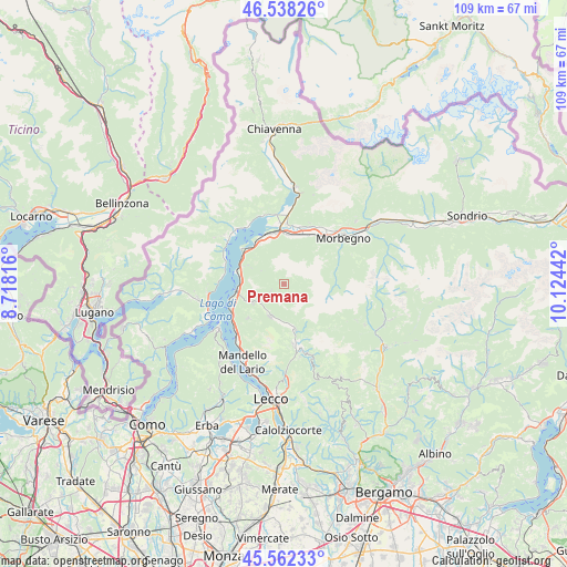
Premana GPS coordinates[2]
46° 3' 8.82" North, 9° 25' 16.644" East
| Map corner | latitude | longitude |
|---|---|---|
| Upper-left | 46.53826°, | 8.71816° |
| Center: | 46.05245°, | 9.42129° |
| Lower-right: | 45.56233°, | 10.12442° |
| Map W x H: | 108.5×108.5 km | = 67.4×67.4mi |
| max Lat: | 47.04031° ⇑6.9% North |
| Premana: | 46.05245° |
| min Lat: | ⇓93.1% South 35.50142° |
| min Long | Premana | max Long |
| 6.69888° | 9.42129° | 18.48682° |
| W 25.8%⇐ | ⇒74.2% E |
Elevation
Elevation of Premana is 955 m = 3133 ft, and this is 648.3 m = 2127 ft above average elevation for this country.
| Max E: |
2085 m = 6841 ft | 3.6% |
| Premana | 955 m 3133 ft | |
| Avg. | 306.7 m = 1006 ft | |
Min E: |
-4 m = -13 ft | 96.4% |
See also: Italy elevation on elevation.city.
Geographical zone
Premana is located in North temperate zone (between Tropic of Cancer and the Arctic Circle). Distance of this North polar circle is 2280.6 km =1417.1 mi to North.| Distance of | km | miles | from Premana |
|---|---|---|---|
| North Pole | 4886.5 | 3036.3 | to North |
| Arctic Circle | 2280.6 | 1417.1 | to North |
| Tropic Cancer | 2514.6 | 1562.5 | to South |
| Equator | 5120.6 | 3181.8 | to South |


Nearby cities:
15 places around Premana: (largest is in red/bold)
• Bellano
8.8 km =5.5 mi,  264°
264°
• Casargo
3 km =1.9 mi,  241°
241°
• Cortenova
6.5 km =4 mi,  206°
206°
• Crandola Valsassina
4.6 km =2.9 mi,  225°
225°
• Introbio
9 km =5.6 mi,  165°
165°
• Introzzo
7 km =4.3 mi,  297°
297°
• Margno
3.9 km =2.4 mi, 232°
• Pagnona
1.6 km =1 mi, 299°
• Parlasco
7 km =4.3 mi, 236°
• Primaluna
7.7 km =4.8 mi, 170°
• Sueglio
7.7 km =4.8 mi, 298°
• Taceno
5.5 km =3.4 mi, 233°
• Tremenico
5 km =3.1 mi, 301°
• Vendrogno
7.4 km =4.6 mi,  254°
254°
• Vestreno
8.2 km =5.1 mi,  294°
294°
Sources, notices
• [Note1] Compared only with cities in Italy existing in our database
• [Src1] Map data: © OpenStreetMap contributors (CC-BY-SA)
• [Src2] Other city data from geonames.org with taken over terms of usage.
• [Src3] Geographical zone / Annual Mean Temperature by Robert A. Rohde @ Wikipedia
