Joppolo geodata
Joppolo (Calabria) is a seat of a third-order administrative division; located in Italy in Europe/Rome (GMT+2) time zone. With population of 750 people, there are 7955 cities with bigger population in this country. Compared to other cities in Italy, 93.9% of cities are located further ↑North; 92.2% of cities are located further ←West and 64.5% of cities have higher elevation than Joppolo. Note1


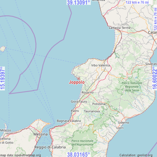
Joppolo GPS coordinates[2]
38° 35' 0.168" North, 15° 53' 49.524" East
| Map corner | latitude | longitude |
|---|---|---|
| Upper-left | 39.13091°, | 15.19397° |
| Center: | 38.58338°, | 15.89709° |
| Lower-right: | 38.03165°, | 16.60022° |
| Map W x H: | 122.2×122.2 km | = 75.9×75.9mi |
| max Lat: | 47.04031° ⇑93.9% North |
| Joppolo: | 38.58338° |
| min Lat: | ⇓6.1% South 35.50142° |
| min Long | Joppolo | max Long |
| 6.69888° | 15.89709° | 18.48682° |
| W 92.2%⇐ | ⇒7.8% E |
Elevation
Elevation of Joppolo is 131 m = 430 ft, and this is 175.7 m = 576 ft below average elevation for this country.
| Max E: |
2085 m = 6841 ft | 64.5% |
| Avg. | 306.7 m = 1006 ft | |
| Joppolo | 131 m = 430 ft | |
Min E: |
-4 m = -13 ft | 35.5% |
See also: Italy elevation on elevation.city.
Geographical zone
Joppolo is located in North temperate zone (between Tropic of Cancer and the Arctic Circle). Distance of this Northern Tropic circle is 1684.2 km =1046.5 mi to South.| Distance of | km | miles | from Joppolo |
|---|---|---|---|
| North Pole | 5717 | 3552.4 | to North |
| Arctic Circle | 3111.1 | 1933.1 | to North |
| Tropic Cancer | 1684.2 | 1046.5 | to South |
| Equator | 4290.1 | 2665.7 | to South |


Nearby cities:
15 places around Joppolo: (largest is in red/bold)
• Brattirò
7 km =4.3 mi,  352°
352°
• Calimera
10.8 km =6.7 mi,  107°
107°
• Caria
7.1 km =4.4 mi,  4°
4°
• Drapia
9.3 km =5.8 mi,  7°
7°
• Limbadi-Caroni
6.4 km =4 mi, 114°
• Nicotera
5.1 km =3.2 mi,  138°
138°
• Pernocari-Presinaci
9.9 km =6.2 mi,  71°
71°
• Ricadi
5.3 km =3.3 mi,  330°
330°
• Rombiolo
9.2 km =5.7 mi,  81°
81°
• San Calogero
10.7 km =6.6 mi,  95°
95°
• San Nicolò
6.9 km =4.3 mi,  324°
324°
• Santa Domenica
9.3 km =5.8 mi,  341°
341°
• Spilinga
5 km =3.1 mi, 8°
• Tropea
10.1 km =6.3 mi,  358°
358°
• Zaccanopoli
9.5 km =5.9 mi,  16°
16°
Sources, notices
• [Note1] Compared only with cities in Italy existing in our database
• [Src1] Map data: © OpenStreetMap contributors (CC-BY-SA)
• [Src2] Other city data from geonames.org with taken over terms of usage.
• [Src3] Geographical zone / Annual Mean Temperature by Robert A. Rohde @ Wikipedia
