Spilinga geodata
Spilinga (Calabria) is a seat of a third-order administrative division; located in Italy in Europe/Rome (GMT+2) time zone. With population of 1,209 people, there are 5929 cities with bigger population in this country. Compared to other cities in Italy, 93.7% of cities are located further ↑North; 92.3% of cities are located further ←West and 73.9% of cities have lower elevation than Spilinga. Note1


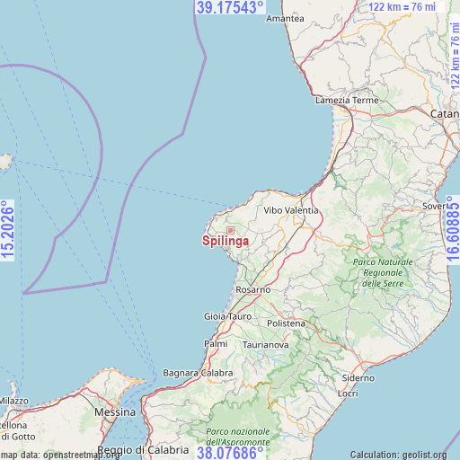
Spilinga GPS coordinates[2]
38° 37' 41.7" North, 15° 54' 20.592" East
| Map corner | latitude | longitude |
|---|---|---|
| Upper-left | 39.17543°, | 15.2026° |
| Center: | 38.62825°, | 15.90572° |
| Lower-right: | 38.07686°, | 16.60885° |
| Map W x H: | 122.1×122.1 km | = 75.9×75.9mi |
| max Lat: | 47.04031° ⇑93.7% North |
| Spilinga: | 38.62825° |
| min Lat: | ⇓6.3% South 35.50142° |
| min Long | Spilinga | max Long |
| 6.69888° | 15.90572° | 18.48682° |
| W 92.3%⇐ | ⇒7.7% E |
Elevation
Elevation of Spilinga is 438 m = 1437 ft, and this is 131.3 m = 431 ft above average elevation for this country.
| Max E: |
2085 m = 6841 ft | 26.1% |
| Spilinga | 438 m 1437 ft | |
| Avg. | 306.7 m = 1006 ft | |
Min E: |
-4 m = -13 ft | 73.9% |
See also: Italy elevation on elevation.city.
Geographical zone
Spilinga is located in North temperate zone (between Tropic of Cancer and the Arctic Circle). Distance of this Northern Tropic circle is 1689.1 km =1049.6 mi to South.| Distance of | km | miles | from Spilinga |
|---|---|---|---|
| North Pole | 5712 | 3549.3 | to North |
| Arctic Circle | 3106.1 | 1930 | to North |
| Tropic Cancer | 1689.1 | 1049.6 | to South |
| Equator | 4295.1 | 2668.9 | to South |


Nearby cities:
15 places around Spilinga: (largest is in red/bold)
• Brattirò
2.5 km =1.6 mi,  319°
319°
• Caria
2.1 km =1.3 mi,  353°
353°
• Drapia
4.2 km =2.6 mi,  6°
6°
• Joppolo
5 km =3.1 mi,  188°
188°
• Limbadi-Caroni
9.2 km =5.7 mi,  146°
146°
• Nicotera
9.2 km =5.7 mi,  163°
163°
• Parghelia
6.1 km =3.8 mi, 12°
• Pernocari-Presinaci
8.8 km =5.5 mi,  101°
101°
• Ricadi
3.4 km =2.1 mi,  264°
264°
• Rombiolo
9.2 km =5.7 mi,  113°
113°
• San Nicolò
4.8 km =3 mi,  278°
278°
• Santa Domenica
5.3 km =3.3 mi, 315°
• Tropea
5.2 km =3.2 mi, 349°
• Zaccanopoli
4.6 km =2.9 mi,  25°
25°
• Zungri
7.5 km =4.7 mi,  65°
65°
Sources, notices
• [Note1] Compared only with cities in Italy existing in our database
• [Src1] Map data: © OpenStreetMap contributors (CC-BY-SA)
• [Src2] Other city data from geonames.org with taken over terms of usage.
• [Src3] Geographical zone / Annual Mean Temperature by Robert A. Rohde @ Wikipedia
