Tropea geodata
Tropea (Calabria) is a seat of a third-order administrative division; located in Italy in Europe/Rome (GMT+2) time zone. With population of 6,489 people, there are 1505 cities with bigger population in this country. Compared to other cities in Italy, 93.5% of cities are located further ↑North; 92.2% of cities are located further ←West and 76.5% of cities have higher elevation than Tropea. Note1


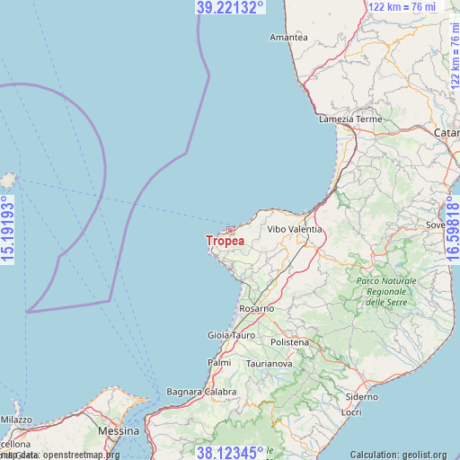
Tropea GPS coordinates[2]
38° 40' 28.164" North, 15° 53' 42.18" East
| Map corner | latitude | longitude |
|---|---|---|
| Upper-left | 39.22132°, | 15.19193° |
| Center: | 38.67449°, | 15.89505° |
| Lower-right: | 38.12345°, | 16.59818° |
| Map W x H: | 122.1×122.1 km | = 75.9×75.9mi |
| max Lat: | 47.04031° ⇑93.5% North |
| Tropea: | 38.67449° |
| min Lat: | ⇓6.5% South 35.50142° |
| min Long | Tropea | max Long |
| 6.69888° | 15.89505° | 18.48682° |
| W 92.2%⇐ | ⇒7.8% E |
Elevation
Elevation of Tropea is 67 m = 220 ft, and this is 239.7 m = 786 ft below average elevation for this country.
| Max E: |
2085 m = 6841 ft | 76.5% |
| Avg. | 306.7 m = 1006 ft | |
| Tropea | 67 m = 220 ft | |
Min E: |
-4 m = -13 ft | 23.5% |
See also: Italy elevation on elevation.city.
Geographical zone
Tropea is located in North temperate zone (between Tropic of Cancer and the Arctic Circle). Distance of this Northern Tropic circle is 1694.3 km =1052.8 mi to South.| Distance of | km | miles | from Tropea |
|---|---|---|---|
| North Pole | 5706.9 | 3546.1 | to North |
| Arctic Circle | 3101 | 1926.9 | to North |
| Tropic Cancer | 1694.3 | 1052.8 | to South |
| Equator | 4300.2 | 2672 | to South |


Nearby cities:
15 places around Tropea: (largest is in red/bold)
• Brattirò
3.3 km =2.1 mi,  192°
192°
• Caria
3.1 km =1.9 mi,  167°
167°
• Cessaniti
11.7 km =7.3 mi,  95°
95°
• Drapia
1.7 km =1.1 mi,  123°
123°
• Joppolo
10.1 km =6.3 mi,  178°
178°
• Parghelia
2.4 km =1.5 mi,  69°
69°
• Pernocari-Presinaci
11.8 km =7.3 mi,  126°
126°
• Ricadi
6 km =3.7 mi,  204°
204°
• San Costantino
10 km =6.2 mi, 70°
• San Nicolò
5.9 km =3.7 mi,  220°
220°
• Santa Domenica
3.1 km =1.9 mi,  243°
243°
• Spilinga
5.2 km =3.2 mi, 169°
• Zaccanopoli
3.1 km =1.9 mi,  108°
108°
• Zambrone
8.7 km =5.4 mi, 71°
• Zungri
8 km =5 mi, 104°
Sources, notices
• [Note1] Compared only with cities in Italy existing in our database
• [Src1] Map data: © OpenStreetMap contributors (CC-BY-SA)
• [Src2] Other city data from geonames.org with taken over terms of usage.
• [Src3] Geographical zone / Annual Mean Temperature by Robert A. Rohde @ Wikipedia
