Caria geodata
Caria (Calabria) is a populated place; located in Italy in Europe/Rome (GMT+2) time zone. With population of 651 people, there are 8629 cities with bigger population in this country. Compared to other cities in Italy, 93.6% of cities are located further ↑North; 92.3% of cities are located further ←West and 74.6% of cities have lower elevation than Caria. Note1


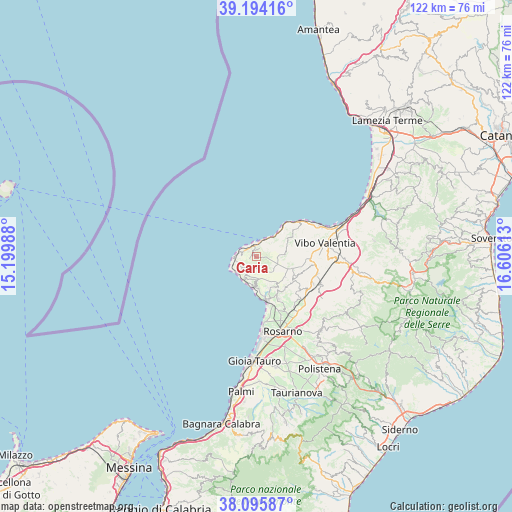
Caria GPS coordinates[2]
38° 38' 49.632" North, 15° 54' 10.8" East
| Map corner | latitude | longitude |
|---|---|---|
| Upper-left | 39.19416°, | 15.19988° |
| Center: | 38.64712°, | 15.903° |
| Lower-right: | 38.09587°, | 16.60613° |
| Map W x H: | 122.1×122.1 km | = 75.9×75.9mi |
| max Lat: | 47.04031° ⇑93.6% North |
| Caria: | 38.64712° |
| min Lat: | ⇓6.4% South 35.50142° |
| min Long | Caria | max Long |
| 6.69888° | 15.903° | 18.48682° |
| W 92.3%⇐ | ⇒7.7% E |
Elevation
Elevation of Caria is 446 m = 1463 ft, and this is 139.3 m = 457 ft above average elevation for this country.
| Max E: |
2085 m = 6841 ft | 25.4% |
| Caria | 446 m 1463 ft | |
| Avg. | 306.7 m = 1006 ft | |
Min E: |
-4 m = -13 ft | 74.6% |
See also: Italy elevation on elevation.city.
Geographical zone
Caria is located in North temperate zone (between Tropic of Cancer and the Arctic Circle). Distance of this Northern Tropic circle is 1691.2 km =1050.9 mi to South.| Distance of | km | miles | from Caria |
|---|---|---|---|
| North Pole | 5709.9 | 3548 | to North |
| Arctic Circle | 3104 | 1928.7 | to North |
| Tropic Cancer | 1691.2 | 1050.9 | to South |
| Equator | 4297.2 | 2670.2 | to South |


Nearby cities:
15 places around Caria: (largest is in red/bold)
• Brattirò
1.4 km =0.9 mi,  262°
262°
• Drapia
2.2 km =1.4 mi,  18°
18°
• Joppolo
7.1 km =4.4 mi,  184°
184°
• Parghelia
4.2 km =2.6 mi, 21°
• Pernocari-Presinaci
9.7 km =6 mi,  113°
113°
• Ricadi
4 km =2.5 mi,  232°
232°
• Rombiolo
10.4 km =6.5 mi,  123°
123°
• San Costantino
10.8 km =6.7 mi,  53°
53°
• San Nicolò
4.7 km =2.9 mi,  252°
252°
• Santa Domenica
3.9 km =2.4 mi,  295°
295°
• Spilinga
2.1 km =1.3 mi,  173°
173°
• Tropea
3.1 km =1.9 mi,  347°
347°
• Zaccanopoli
3 km =1.9 mi, 47°
• Zambrone
9.5 km =5.9 mi, 52°
• Zungri
7.1 km =4.4 mi,  81°
81°
Sources, notices
• [Note1] Compared only with cities in Italy existing in our database
• [Src1] Map data: © OpenStreetMap contributors (CC-BY-SA)
• [Src2] Other city data from geonames.org with taken over terms of usage.
• [Src3] Geographical zone / Annual Mean Temperature by Robert A. Rohde @ Wikipedia
