Casi geodata
Casi (Campania) is a populated place; located in Italy in Europe/Rome (GMT+2) time zone. With population of 560 people, there are 9347 cities with bigger population in this country. Compared to other cities in Italy, 76.4% of cities are located further ↑North; 78.4% of cities are located further ←West and 55.1% of cities have lower elevation than Casi. Note1


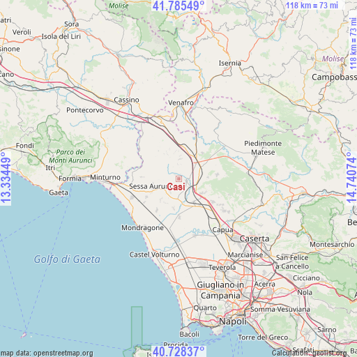
Casi GPS coordinates[2]
41° 15' 32.652" North, 14° 2' 15.396" East
| Map corner | latitude | longitude |
|---|---|---|
| Upper-left | 41.78549°, | 13.33449° |
| Center: | 41.25907°, | 14.03761° |
| Lower-right: | 40.72837°, | 14.74074° |
| Map W x H: | 117.5×117.5 km | = 73×73mi |
| max Lat: | 47.04031° ⇑76.4% North |
| Casi: | 41.25907° |
| min Lat: | ⇓23.6% South 35.50142° |
| min Long | Casi | max Long |
| 6.69888° | 14.03761° | 18.48682° |
| W 78.4%⇐ | ⇒21.6% E |
Elevation
Elevation of Casi is 266 m = 873 ft, and this is 40.7 m = 134 ft below average elevation for this country.
| Max E: |
2085 m = 6841 ft | 44.9% |
| Avg. | 306.7 m = 1006 ft | |
| Casi | 266 m = 873 ft | |
Min E: |
-4 m = -13 ft | 55.1% |
See also: Italy elevation on elevation.city.
Geographical zone
Casi is located in North temperate zone (between Tropic of Cancer and the Arctic Circle). Distance of this Northern Tropic circle is 1981.7 km =1231.4 mi to South.| Distance of | km | miles | from Casi |
|---|---|---|---|
| North Pole | 5419.5 | 3367.5 | to North |
| Arctic Circle | 2813.6 | 1748.3 | to North |
| Tropic Cancer | 1981.7 | 1231.4 | to South |
| Equator | 4587.6 | 2850.6 | to South |


Nearby cities:
15 places around Casi: (largest is in red/bold)
• Caianello
6.5 km =4 mi,  37°
37°
• Casale
5.3 km =3.3 mi,  214°
214°
• Cascano
6.4 km =4 mi,  242°
242°
• Conca della Campania
9 km =5.6 mi,  334°
334°
• Francolise
8.4 km =5.2 mi,  169°
169°
• Grottola
6.5 km =4 mi,  2°
2°
• Marzanello
9 km =5.6 mi,  46°
46°
• Marzano Appio
6.6 km =4.1 mi,  5°
5°
• Montano
7.5 km =4.7 mi, 45°
• Roccamonfina
5.8 km =3.6 mi,  302°
302°
• San Marco
4.2 km =2.6 mi,  199°
199°
• Santa Lucia
6.1 km =3.8 mi,  34°
34°
• Scalo Ferroviario
4.3 km =2.7 mi,  133°
133°
• Teano
2.6 km =1.6 mi,  109°
109°
• Zuni
9.1 km =5.7 mi,  120°
120°
Sources, notices
• [Note1] Compared only with cities in Italy existing in our database
• [Src1] Map data: © OpenStreetMap contributors (CC-BY-SA)
• [Src2] Other city data from geonames.org with taken over terms of usage.
• [Src3] Geographical zone / Annual Mean Temperature by Robert A. Rohde @ Wikipedia
