Turate geodata
Turate (Lombardy) is a seat of a third-order administrative division; located in Italy in Europe/Rome (GMT+2) time zone. With population of 8,581 people, there are 1110 cities with bigger population in this country. Compared to other cities in Italy, 79.3% of cities are located further ↓South; 81.2% of cities are located further →East and 51.7% of cities have lower elevation than Turate. Note1


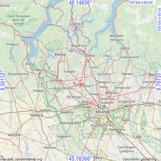
Turate GPS coordinates[2]
45° 39' 26.172" North, 9° 0' 15.264" East
| Map corner | latitude | longitude |
|---|---|---|
| Upper-left | 46.14656°, | 8.30112° |
| Center: | 45.65727°, | 9.00424° |
| Lower-right: | 45.16366°, | 9.70737° |
| Map W x H: | 109.3×109.3 km | = 67.9×67.9mi |
| max Lat: | 47.04031° ⇑20.7% North |
| Turate: | 45.65727° |
| min Lat: | ⇓79.3% South 35.50142° |
| min Long | Turate | max Long |
| 6.69888° | 9.00424° | 18.48682° |
| W 18.8%⇐ | ⇒81.2% E |
Elevation
Elevation of Turate is 245 m = 804 ft, and this is 61.7 m = 202 ft below average elevation for this country.
| Max E: |
2085 m = 6841 ft | 48.3% |
| Avg. | 306.7 m = 1006 ft | |
| Turate | 245 m = 804 ft | |
Min E: |
-4 m = -13 ft | 51.7% |
See also: Italy elevation on elevation.city.
Geographical zone
Turate is located in North temperate zone (between Tropic of Cancer and the Arctic Circle). Distance of this North polar circle is 2324.6 km =1444.4 mi to North.| Distance of | km | miles | from Turate |
|---|---|---|---|
| North Pole | 4930.4 | 3063.6 | to North |
| Arctic Circle | 2324.6 | 1444.4 | to North |
| Tropic Cancer | 2470.7 | 1535.2 | to South |
| Equator | 5076.6 | 3154.5 | to South |


Nearby cities:
15 places around Turate: (largest is in red/bold)
• Cascina Nuova
4.7 km =2.9 mi,  95°
95°
• Cascina Restelli
2.9 km =1.8 mi,  336°
336°
• Cirimido
4.8 km =3 mi,  7°
7°
• Cislago
2.5 km =1.6 mi,  275°
275°
• Dal Pozzo
4.9 km =3 mi,  126°
126°
• Fenegrò
4.9 km =3 mi,  355°
355°
• Gerenzano
2 km =1.2 mi,  187°
187°
• Limido Comasco
4 km =2.5 mi,  331°
331°
• Manera
3.3 km =2.1 mi,  57°
57°
• Massina
2.7 km =1.7 mi,  239°
239°
• Mozzate
4.2 km =2.6 mi,  297°
297°
• Rovellasca
3.6 km =2.2 mi,  73°
73°
• Rovello Porro
2.8 km =1.7 mi, 101°
• Saronno
4.3 km =2.7 mi,  146°
146°
• Uboldo
4.7 km =2.9 mi,  180°
180°
Sources, notices
• [Note1] Compared only with cities in Italy existing in our database
• [Src1] Map data: © OpenStreetMap contributors (CC-BY-SA)
• [Src2] Other city data from geonames.org with taken over terms of usage.
• [Src3] Geographical zone / Annual Mean Temperature by Robert A. Rohde @ Wikipedia
