Uboldo geodata
Uboldo (Lombardy) is a seat of a third-order administrative division; located in Italy in Europe/Rome (GMT+2) time zone. With population of 9,762 people, there are 973 cities with bigger population in this country. Compared to other cities in Italy, 77.7% of cities are located further ↓South; 81.2% of cities are located further →East and 54.3% of cities have higher elevation than Uboldo. Note1


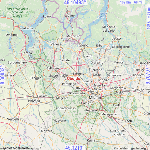
Uboldo GPS coordinates[2]
45° 36' 54.972" North, 9° 0' 14.184" East
| Map corner | latitude | longitude |
|---|---|---|
| Upper-left | 46.10493°, | 8.30082° |
| Center: | 45.61527°, | 9.00394° |
| Lower-right: | 45.1213°, | 9.70707° |
| Map W x H: | 109.4×109.4 km | = 68×68mi |
| max Lat: | 47.04031° ⇑22.3% North |
| Uboldo: | 45.61527° |
| min Lat: | ⇓77.7% South 35.50142° |
| min Long | Uboldo | max Long |
| 6.69888° | 9.00394° | 18.48682° |
| W 18.8%⇐ | ⇒81.2% E |
Elevation
Elevation of Uboldo is 207 m = 679 ft, and this is 99.7 m = 327 ft below average elevation for this country.
| Max E: |
2085 m = 6841 ft | 54.3% |
| Avg. | 306.7 m = 1006 ft | |
| Uboldo | 207 m = 679 ft | |
Min E: |
-4 m = -13 ft | 45.7% |
See also: Italy elevation on elevation.city.
Geographical zone
Uboldo is located in North temperate zone (between Tropic of Cancer and the Arctic Circle). Distance of this North polar circle is 2329.2 km =1447.3 mi to North.| Distance of | km | miles | from Uboldo |
|---|---|---|---|
| North Pole | 4935.1 | 3066.5 | to North |
| Arctic Circle | 2329.2 | 1447.3 | to North |
| Tropic Cancer | 2466 | 1532.3 | to South |
| Equator | 5071.9 | 3151.5 | to South |


Nearby cities:
15 places around Uboldo: (largest is in red/bold)
• Cantalupo
4.5 km =2.8 mi,  201°
201°
• Caronno Pertusella
3.8 km =2.4 mi,  120°
120°
• Cerro Maggiore
4.5 km =2.8 mi,  238°
238°
• Cesate
6 km =3.7 mi,  111°
111°
• Cislago
5.5 km =3.4 mi,  333°
333°
• Dal Pozzo
4.3 km =2.7 mi,  65°
65°
• Gerenzano
2.7 km =1.7 mi,  355°
355°
• Lainate
5.2 km =3.2 mi,  159°
159°
• Massina
4 km =2.5 mi,  324°
324°
• Origgio
2.3 km =1.4 mi,  154°
154°
• Rescaldina
4.3 km =2.7 mi,  277°
277°
• Rovello Porro
4.9 km =3 mi,  33°
33°
• San Vittore Olona
5.9 km =3.7 mi, 236°
• Saronno
2.7 km =1.7 mi, 65°
• Turate
4.7 km =2.9 mi,  0°
0°
Sources, notices
• [Note1] Compared only with cities in Italy existing in our database
• [Src1] Map data: © OpenStreetMap contributors (CC-BY-SA)
• [Src2] Other city data from geonames.org with taken over terms of usage.
• [Src3] Geographical zone / Annual Mean Temperature by Robert A. Rohde @ Wikipedia
