Pizzale geodata
Pizzale (Lombardy) is a seat of a third-order administrative division; located in Italy in Europe/Rome (GMT+2) time zone. With population of 573 people, there are 9238 cities with bigger population in this country. Compared to other cities in Italy, 60.9% of cities are located further ↓South; 80.5% of cities are located further →East and 74.3% of cities have higher elevation than Pizzale. Note1


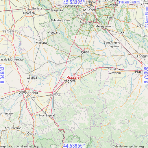
Pizzale GPS coordinates[2]
45° 2' 18.816" North, 9° 2' 59.82" East
| Map corner | latitude | longitude |
|---|---|---|
| Upper-left | 45.53325°, | 8.34683° |
| Center: | 45.03856°, | 9.04995° |
| Lower-right: | 44.53955°, | 9.75308° |
| Map W x H: | 110.5×110.5 km | = 68.7×68.7mi |
| max Lat: | 47.04031° ⇑39.1% North |
| Pizzale: | 45.03856° |
| min Lat: | ⇓60.9% South 35.50142° |
| min Long | Pizzale | max Long |
| 6.69888° | 9.04995° | 18.48682° |
| W 19.5%⇐ | ⇒80.5% E |
Elevation
Elevation of Pizzale is 77 m = 253 ft, and this is 229.7 m = 754 ft below average elevation for this country.
| Max E: |
2085 m = 6841 ft | 74.3% |
| Avg. | 306.7 m = 1006 ft | |
| Pizzale | 77 m = 253 ft | |
Min E: |
-4 m = -13 ft | 25.7% |
See also: Italy elevation on elevation.city.
Geographical zone
Pizzale is located in North temperate zone (between Tropic of Cancer and the Arctic Circle). Distance of this North polar circle is 2393.4 km =1487.2 mi to North.| Distance of | km | miles | from Pizzale |
|---|---|---|---|
| North Pole | 4999.2 | 3106.4 | to North |
| Arctic Circle | 2393.4 | 1487.2 | to North |
| Tropic Cancer | 2401.9 | 1492.5 | to South |
| Equator | 5007.8 | 3111.7 | to South |


Nearby cities:
15 places around Pizzale: (largest is in red/bold)
• Bastida Pancarana
6 km =3.7 mi,  27°
27°
• Bressana
7.7 km =4.8 mi,  55°
55°
• Casatisma
6.4 km =4 mi,  82°
82°
• Casteggio
6.5 km =4 mi,  114°
114°
• Castelletto Po
5.2 km =3.2 mi,  49°
49°
• Castelletto di Branduzzo
5.1 km =3.2 mi, 48°
• Cervesina
3.6 km =2.2 mi,  313°
313°
• Corana
6.9 km =4.3 mi,  293°
293°
• Lungavilla
2.3 km =1.4 mi, 81°
• Mezzana Rabattone
6.4 km =4 mi,  347°
347°
• Montebello
6 km =3.7 mi,  136°
136°
• Pancarana
4.1 km =2.5 mi,  1°
1°
• Torrazza Coste
7 km =4.3 mi,  162°
162°
• Verretto
5 km =3.1 mi,  88°
88°
• Voghera
6 km =3.7 mi,  209°
209°
Sources, notices
• [Note1] Compared only with cities in Italy existing in our database
• [Src1] Map data: © OpenStreetMap contributors (CC-BY-SA)
• [Src2] Other city data from geonames.org with taken over terms of usage.
• [Src3] Geographical zone / Annual Mean Temperature by Robert A. Rohde @ Wikipedia
