Corana geodata
Corana (Lombardy) is a seat of a third-order administrative division; located in Italy in Europe/Rome (GMT+2) time zone. With population of 353 people, there are 10466 cities with bigger population in this country. Compared to other cities in Italy, 61.5% of cities are located further ↓South; 81.7% of cities are located further →East and 75.6% of cities have higher elevation than Corana. Note1


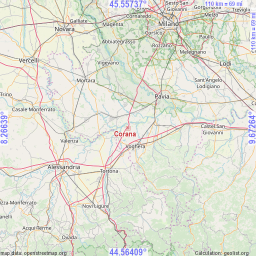
Corana GPS coordinates[2]
45° 3' 46.404" North, 8° 58' 10.272" East
| Map corner | latitude | longitude |
|---|---|---|
| Upper-left | 45.55737°, | 8.26639° |
| Center: | 45.06289°, | 8.96952° |
| Lower-right: | 44.56409°, | 9.67264° |
| Map W x H: | 110.4×110.4 km | = 68.6×68.6mi |
| max Lat: | 47.04031° ⇑38.5% North |
| Corana: | 45.06289° |
| min Lat: | ⇓61.5% South 35.50142° |
| min Long | Corana | max Long |
| 6.69888° | 8.96952° | 18.48682° |
| W 18.3%⇐ | ⇒81.7% E |
Elevation
Elevation of Corana is 71 m = 233 ft, and this is 235.7 m = 773 ft below average elevation for this country.
| Max E: |
2085 m = 6841 ft | 75.6% |
| Avg. | 306.7 m = 1006 ft | |
| Corana | 71 m = 233 ft | |
Min E: |
-4 m = -13 ft | 24.4% |
See also: Italy elevation on elevation.city.
Geographical zone
Corana is located in North temperate zone (between Tropic of Cancer and the Arctic Circle). Distance of this North polar circle is 2390.7 km =1485.5 mi to North.| Distance of | km | miles | from Corana |
|---|---|---|---|
| North Pole | 4996.5 | 3104.7 | to North |
| Arctic Circle | 2390.7 | 1485.5 | to North |
| Tropic Cancer | 2404.6 | 1494.1 | to South |
| Equator | 5010.5 | 3113.4 | to South |


Nearby cities:
15 places around Corana: (largest is in red/bold)
• Alzano Scrivia
8.6 km =5.3 mi,  234°
234°
• Bastida de' Dossi
4.6 km =2.9 mi,  235°
235°
• Casei
7 km =4.3 mi,  208°
208°
• Cervesina
3.7 km =2.3 mi,  94°
94°
• Cornale
5.1 km =3.2 mi, 244°
• Mezzana Rabattone
6.1 km =3.8 mi,  54°
54°
• Molino dei Torti
7.3 km =4.5 mi, 234°
• Pancarana
6.6 km =4.1 mi,  77°
77°
• Pieve Albignola
5.6 km =3.5 mi,  352°
352°
• Pizzale
6.9 km =4.3 mi,  113°
113°
• Sannazzaro de' Burgondi
6.6 km =4.1 mi,  311°
311°
• Scaldasole
8.3 km =5.2 mi,  326°
326°
• Silvano Pietra
3.2 km =2 mi, 214°
• Voghera
8.6 km =5.3 mi,  157°
157°
• Zinasco Nuovo
7 km =4.3 mi,  20°
20°
Sources, notices
• [Note1] Compared only with cities in Italy existing in our database
• [Src1] Map data: © OpenStreetMap contributors (CC-BY-SA)
• [Src2] Other city data from geonames.org with taken over terms of usage.
• [Src3] Geographical zone / Annual Mean Temperature by Robert A. Rohde @ Wikipedia
