Vambolieri geodata
Vambolieri (Sicily) is a section of populated place; located in Italy in Europe/Rome (GMT+2) time zone. With population of 1,546 people, there are 5019 cities with bigger population in this country. Compared to other cities in Italy, 98.6% of cities are located further ↑North; 88.5% of cities are located further ←West and 69.2% of cities have higher elevation than Vambolieri. Note1


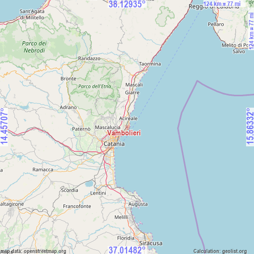
Vambolieri GPS coordinates[2]
37° 34' 27.012" North, 15° 9' 36.684" East
| Map corner | latitude | longitude |
|---|---|---|
| Upper-left | 38.12935°, | 14.45707° |
| Center: | 37.57417°, | 15.16019° |
| Lower-right: | 37.01482°, | 15.86332° |
| Map W x H: | 123.9×123.9 km | = 77×77mi |
| max Lat: | 47.04031° ⇑98.6% North |
| Vambolieri: | 37.57417° |
| min Lat: | ⇓1.4% South 35.50142° |
| min Long | Vambolieri | max Long |
| 6.69888° | 15.16019° | 18.48682° |
| W 88.5%⇐ | ⇒11.5% E |
Elevation
Elevation of Vambolieri is 102 m = 335 ft, and this is 204.7 m = 672 ft below average elevation for this country.
| Max E: |
2085 m = 6841 ft | 69.2% |
| Avg. | 306.7 m = 1006 ft | |
| Vambolieri | 102 m = 335 ft | |
Min E: |
-4 m = -13 ft | 30.8% |
See also: Italy elevation on elevation.city.
Geographical zone
Vambolieri is located in North temperate zone (between Tropic of Cancer and the Arctic Circle). Distance of this Northern Tropic circle is 1571.9 km =976.7 mi to South.| Distance of | km | miles | from Vambolieri |
|---|---|---|---|
| North Pole | 5829.2 | 3622.1 | to North |
| Arctic Circle | 3223.3 | 2002.9 | to North |
| Tropic Cancer | 1571.9 | 976.7 | to South |
| Equator | 4177.9 | 2596 | to South |


Nearby cities:
15 places around Vambolieri: (largest is in red/bold)
• Aci Bonaccorsi
5.3 km =3.3 mi,  297°
297°
• Aci Castello
2.4 km =1.5 mi,  212°
212°
• Aci Catena
3.9 km =2.4 mi,  335°
335°
• Aci Sant'Antonio
4.7 km =2.9 mi,  316°
316°
• Aci Trezza
1.2 km =0.7 mi,  174°
174°
• Acireale
3.9 km =2.4 mi,  7°
7°
• Acitrezza
1.6 km =1 mi,  180°
180°
• Canalicchio
6.7 km =4.2 mi,  236°
236°
• Carrubazza-Motta
5.1 km =3.2 mi, 243°
• Cerza
6 km =3.7 mi,  234°
234°
• Maugeri
4 km =2.5 mi,  289°
289°
• San Giovanni la Punta
5.9 km =3.7 mi,  272°
272°
• San Gregorio di Catania
4.4 km =2.7 mi,  260°
260°
• Santa Maria la Stella
6.5 km =4 mi,  327°
327°
• Valverde
3.2 km =2 mi,  275°
275°
Sources, notices
• [Note1] Compared only with cities in Italy existing in our database
• [Src1] Map data: © OpenStreetMap contributors (CC-BY-SA)
• [Src2] Other city data from geonames.org with taken over terms of usage.
• [Src3] Geographical zone / Annual Mean Temperature by Robert A. Rohde @ Wikipedia
