Santa Maria la Stella geodata
Santa Maria la Stella (Sicily) is a populated place; located in Italy in Europe/Rome (GMT+2) time zone. With population of 4,467 people, there are 2159 cities with bigger population in this country. Compared to other cities in Italy, 98.4% of cities are located further ↑North; 88.2% of cities are located further ←West and 64.8% of cities have lower elevation than Santa Maria la Stella. Note1
Current local time in Santa Maria la Stella:
12:46 AM, WednesdayDifference from your time zone: hours


Santa Maria la Stella GPS coordinates[2]
37° 37' 24.564" North, 15° 7' 14.556" East
| Map corner | latitude | longitude |
|---|---|---|
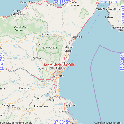
| Upper-left | 38.1783°, | 14.41759° |
| Center: | 37.62349°, | 15.12071° |
| Lower-right: | 37.0645°, | 15.82384° |
| Map W x H: | 123.8×123.8 km | = 76.9×76.9mi |
| max Lat: | 47.04031° ⇑98.4% North |
| Santa Maria la Stella: | 37.62349° |
| min Lat: | ⇓1.6% South 35.50142° |
| min Long | Santa Maria la | max Long |
| 6.69888° | 15.12071° | 18.48682° |
| W 88.2%⇐ | ⇒11.8% E |
Elevation
Elevation of Santa Maria la Stella is 341 m = 1119 ft, and this is 34.3 m = 113 ft above average elevation for this country.
| Max E: |
2085 m = 6841 ft | 35.2% |
| Santa Maria la Stella | 341 m 1119 ft | |
| Avg. | 306.7 m = 1006 ft | |
Min E: |
-4 m = -13 ft | 64.8% |
See also: Italy elevation on elevation.city.
Geographical zone
Santa Maria la Stella is located in North temperate zone (between Tropic of Cancer and the Arctic Circle). Distance of this Northern Tropic circle is 1577.4 km =980.2 mi to South.| Distance of | km | miles | from Santa Maria la Stella |
|---|---|---|---|
| North Pole | 5823.7 | 3618.7 | to North |
| Arctic Circle | 3217.8 | 1999.4 | to North |
| Tropic Cancer | 1577.4 | 980.2 | to South |
| Equator | 4183.3 | 2599.4 | to South |


Nearby cities:
15 places around Santa Maria la Stella: (largest is in red/bold)
• Aci Bonaccorsi
3.2 km =2 mi,  201°
201°
• Aci Catena
2.7 km =1.7 mi,  136°
136°
• Aci Sant'Antonio
2.1 km =1.3 mi,  174°
174°
• Acireale
4.3 km =2.7 mi,  112°
112°
• Lavinaio-Monterosso
2.4 km =1.5 mi,  323°
323°
• Linera
4.7 km =2.9 mi,  17°
17°
• Maugeri
4.2 km =2.6 mi,  183°
183°
• Monterosso
3.4 km =2.1 mi,  309°
309°
• Pedara
5.6 km =3.5 mi,  270°
270°
• Pennisi
2.9 km =1.8 mi,  5°
5°
• San Giovanni la Punta
5.7 km =3.5 mi, 204°
• San Gregorio di Catania
6.3 km =3.9 mi,  187°
187°
• Trecastagni
3.9 km =2.4 mi,  256°
256°
• Valverde
5.2 km =3.2 mi, 176°
• Viagrande
2.5 km =1.6 mi,  233°
233°
Sources, notices
• [Note1] Compared only with cities in Italy existing in our database
• [Src1] Map data: © OpenStreetMap contributors (CC-BY-SA)
• [Src2] Other city data from geonames.org with taken over terms of usage.
• [Src3] Geographical zone / Annual Mean Temperature by Robert A. Rohde @ Wikipedia
