Acireale geodata
Acireale (Sicily) is a seat of a third-order administrative division; located in Italy in Europe/Rome (GMT+2) time zone. With population of 49,477 people, there are 117 cities with bigger population in this country. Compared to other cities in Italy, 98.4% of cities are located further ↑North; 88.5% of cities are located further ←West and 61% of cities have higher elevation than Acireale. Note1


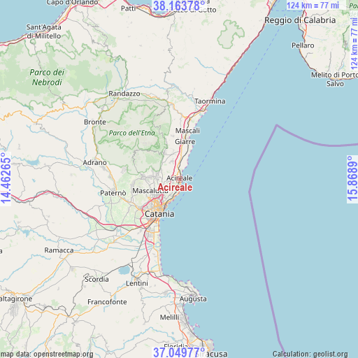
Acireale GPS coordinates[2]
37° 36' 31.896" North, 15° 9' 56.772" East
| Map corner | latitude | longitude |
|---|---|---|
| Upper-left | 38.16378°, | 14.46265° |
| Center: | 37.60886°, | 15.16577° |
| Lower-right: | 37.04977°, | 15.8689° |
| Map W x H: | 123.9×123.9 km | = 77×77mi |
| max Lat: | 47.04031° ⇑98.4% North |
| Acireale: | 37.60886° |
| min Lat: | ⇓1.6% South 35.50142° |
| min Long | Acireale | max Long |
| 6.69888° | 15.16577° | 18.48682° |
| W 88.5%⇐ | ⇒11.5% E |
Elevation
Elevation of Acireale is 155 m = 509 ft, and this is 151.7 m = 498 ft below average elevation for this country.
| Max E: |
2085 m = 6841 ft | 61% |
| Avg. | 306.7 m = 1006 ft | |
| Acireale | 155 m = 509 ft | |
Min E: |
-4 m = -13 ft | 39% |
See also: Acireale elevation on elevation.city.
Geographical zone
Acireale is located in North temperate zone (between Tropic of Cancer and the Arctic Circle). Distance of this Northern Tropic circle is 1575.8 km =979.2 mi to South.| Distance of | km | miles | from Acireale |
|---|---|---|---|
| North Pole | 5825.3 | 3619.7 | to North |
| Arctic Circle | 3219.5 | 2000.5 | to North |
| Tropic Cancer | 1575.8 | 979.2 | to South |
| Equator | 4181.7 | 2598.4 | to South |


Nearby cities:
15 places around Acireale: (largest is in red/bold)
• Aci Bonaccorsi
5.3 km =3.3 mi,  254°
254°
• Aci Castello
6.2 km =3.9 mi,  196°
196°
• Aci Catena
2.1 km =1.3 mi,  261°
261°
• Aci Sant'Antonio
3.8 km =2.4 mi, 263°
• Aci Trezza
5 km =3.1 mi,  184°
184°
• Acitrezza
5.5 km =3.4 mi,  185°
185°
• Lavinaio-Monterosso
6.5 km =4 mi,  303°
303°
• Linera
6.6 km =4.1 mi,  337°
337°
• Maugeri
4.9 km =3 mi,  239°
239°
• Pennisi
5.8 km =3.6 mi,  320°
320°
• San Gregorio di Catania
6.6 km =4.1 mi,  226°
226°
• Santa Maria la Stella
4.3 km =2.7 mi,  292°
292°
• Valverde
5.1 km =3.2 mi, 225°
• Vambolieri
3.9 km =2.4 mi, 187°
• Viagrande
6 km =3.7 mi,  271°
271°
Sources, notices
• [Note1] Compared only with cities in Italy existing in our database
• [Src1] Map data: © OpenStreetMap contributors (CC-BY-SA)
• [Src2] Other city data from geonames.org with taken over terms of usage.
• [Src3] Geographical zone / Annual Mean Temperature by Robert A. Rohde @ Wikipedia
