Borgonato geodata
Borgonato (Lombardy) is a populated place; located in Italy in Europe/Rome (GMT+2) time zone. With population of 532 people, there are 9625 cities with bigger population in this country. Compared to other cities in Italy, 77.9% of cities are located further ↓South; 67.6% of cities are located further →East and 54.2% of cities have higher elevation than Borgonato. Note1


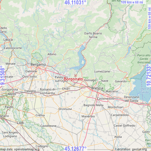
Borgonato GPS coordinates[2]
45° 37' 14.52" North, 10° 1' 5.52" East
| Map corner | latitude | longitude |
|---|---|---|
| Upper-left | 46.11031°, | 9.31508° |
| Center: | 45.6207°, | 10.0182° |
| Lower-right: | 45.12677°, | 10.72133° |
| Map W x H: | 109.4×109.4 km | = 68×68mi |
| max Lat: | 47.04031° ⇑22.1% North |
| Borgonato: | 45.6207° |
| min Lat: | ⇓77.9% South 35.50142° |
| min Long | Borgonato | max Long |
| 6.69888° | 10.0182° | 18.48682° |
| W 32.4%⇐ | ⇒67.6% E |
Elevation
Elevation of Borgonato is 208 m = 682 ft, and this is 98.7 m = 324 ft below average elevation for this country.
| Max E: |
2085 m = 6841 ft | 54.2% |
| Avg. | 306.7 m = 1006 ft | |
| Borgonato | 208 m = 682 ft | |
Min E: |
-4 m = -13 ft | 45.8% |
See also: Italy elevation on elevation.city.
Geographical zone
Borgonato is located in North temperate zone (between Tropic of Cancer and the Arctic Circle). Distance of this North polar circle is 2328.6 km =1446.9 mi to North.| Distance of | km | miles | from Borgonato |
|---|---|---|---|
| North Pole | 4934.5 | 3066.2 | to North |
| Arctic Circle | 2328.6 | 1446.9 | to North |
| Tropic Cancer | 2466.6 | 1532.7 | to South |
| Equator | 5072.5 | 3151.9 | to South |


Nearby cities:
15 places around Borgonato: (largest is in red/bold)
• Adro
4.4 km =2.7 mi,  269°
269°
• Bornato
3.5 km =2.2 mi,  149°
149°
• Cazzago San Martino-Calino
4.1 km =2.5 mi,  174°
174°
• Colombaro-Timoline
3.2 km =2 mi,  324°
324°
• Corte Franca
2.5 km =1.6 mi,  294°
294°
• Costa-Barco
4.5 km =2.8 mi,  158°
158°
• Cremignane
3.2 km =2 mi,  359°
359°
• Erbusco
4.4 km =2.7 mi,  235°
235°
• Fontane-Zurane-Gresine
2.7 km =1.7 mi,  58°
58°
• Monterotondo
2.4 km =1.5 mi,  123°
123°
• Nigoline-Bonomelli
2.6 km =1.6 mi, 290°
• Provaglio d'Iseo
2.6 km =1.6 mi,  51°
51°
• Provezze
4.4 km =2.7 mi,  74°
74°
• Torbiato
2.9 km =1.8 mi,  249°
249°
• Villa Pedergnano
4.4 km =2.7 mi,  205°
205°
Sources, notices
• [Note1] Compared only with cities in Italy existing in our database
• [Src1] Map data: © OpenStreetMap contributors (CC-BY-SA)
• [Src2] Other city data from geonames.org with taken over terms of usage.
• [Src3] Geographical zone / Annual Mean Temperature by Robert A. Rohde @ Wikipedia
