Cerbara geodata
Cerbara (Umbria) is a populated place; located in Italy in Europe/Rome (GMT+2) time zone. With population of 1,955 people, there are 4237 cities with bigger population in this country. Compared to other cities in Italy, 59.8% of cities are located further ↑North; 58.7% of cities are located further ←West and 59.8% of cities have lower elevation than Cerbara. Note1
Administrative division(s):
- Level 1: Umbria
- Level 2: Provincia di Perugia
- Level 3: Città di Castello


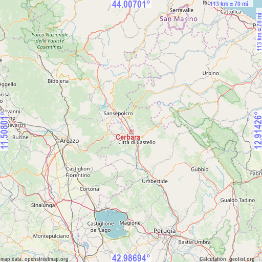
Cerbara GPS coordinates[2]
43° 29' 56.868" North, 12° 12' 40.068" East
| Map corner | latitude | longitude |
|---|---|---|
| Upper-left | 44.00701°, | 11.50801° |
| Center: | 43.49913°, | 12.21113° |
| Lower-right: | 42.98694°, | 12.91426° |
| Map W x H: | 113.4×113.4 km | = 70.5×70.5mi |
| max Lat: | 47.04031° ⇑59.8% North |
| Cerbara: | 43.49913° |
| min Lat: | ⇓40.2% South 35.50142° |
| min Long | Cerbara | max Long |
| 6.69888° | 12.21113° | 18.48682° |
| W 58.7%⇐ | ⇒41.3% E |
Elevation
Elevation of Cerbara is 298 m = 978 ft, and this is 8.7 m = 29 ft below average elevation for this country.
| Max E: |
2085 m = 6841 ft | 40.2% |
| Avg. | 306.7 m = 1006 ft | |
| Cerbara | 298 m = 978 ft | |
Min E: |
-4 m = -13 ft | 59.8% |
See also: Italy elevation on elevation.city.
Geographical zone
Cerbara is located in North temperate zone (between Tropic of Cancer and the Arctic Circle). Distance of this Northern Tropic circle is 2230.7 km =1386.1 mi to South.| Distance of | km | miles | from Cerbara |
|---|---|---|---|
| North Pole | 5170.4 | 3212.7 | to North |
| Arctic Circle | 2564.5 | 1593.5 | to North |
| Tropic Cancer | 2230.7 | 1386.1 | to South |
| Equator | 4836.6 | 3005.3 | to South |


Nearby cities:
15 places around Cerbara: (largest is in red/bold)
• Anghiari
13.2 km =8.2 mi,  290°
290°
• Citerna
7.9 km =4.9 mi,  269°
269°
• Città di Castello
4.3 km =2.7 mi,  150°
150°
• Fighille
8.6 km =5.3 mi,  284°
284°
• Lerchi
2.8 km =1.7 mi,  200°
200°
• Monte Santa Maria Tiberina
8 km =5 mi,  209°
209°
• Monterchi
8.2 km =5.1 mi,  260°
260°
• Piosina
1.5 km =0.9 mi,  218°
218°
• Pistrino
4.9 km =3 mi, 283°
• San Giustino
6 km =3.7 mi,  331°
331°
• San Secondo
10.7 km =6.6 mi,  170°
170°
• Sansepolcro
10 km =6.2 mi,  324°
324°
• Santa Fiora
10.4 km =6.5 mi,  310°
310°
• Selci-Lama
2 km =1.2 mi,  4°
4°
• Trestina
15 km =9.3 mi, 171°
Sources, notices
• [Note1] Compared only with cities in Italy existing in our database
• [Src1] Map data: © OpenStreetMap contributors (CC-BY-SA)
• [Src2] Other city data from geonames.org with taken over terms of usage.
• [Src3] Geographical zone / Annual Mean Temperature by Robert A. Rohde @ Wikipedia
