Anghiari geodata
Anghiari (Tuscany) is a seat of a third-order administrative division; located in Italy in Europe/Rome (GMT+2) time zone. With population of 2,784 people, there are 3230 cities with bigger population in this country. Compared to other cities in Italy, 59.5% of cities are located further ↑North; 56.7% of cities are located further ←West and 70.5% of cities have lower elevation than Anghiari. Note1


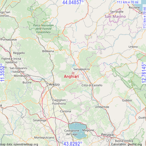
Anghiari GPS coordinates[2]
43° 32' 27.744" North, 12° 3' 29.952" East
| Map corner | latitude | longitude |
|---|---|---|
| Upper-left | 44.04857°, | 11.3552° |
| Center: | 43.54104°, | 12.05832° |
| Lower-right: | 43.0292°, | 12.76145° |
| Map W x H: | 113.3×113.3 km | = 70.4×70.4mi |
| max Lat: | 47.04031° ⇑59.5% North |
| Anghiari: | 43.54104° |
| min Lat: | ⇓40.5% South 35.50142° |
| min Long | Anghiari | max Long |
| 6.69888° | 12.05832° | 18.48682° |
| W 56.7%⇐ | ⇒43.3% E |
Elevation
Elevation of Anghiari is 399 m = 1309 ft, and this is 92.3 m = 303 ft above average elevation for this country.
| Max E: |
2085 m = 6841 ft | 29.5% |
| Anghiari | 399 m 1309 ft | |
| Avg. | 306.7 m = 1006 ft | |
Min E: |
-4 m = -13 ft | 70.5% |
See also: Italy elevation on elevation.city.
Geographical zone
Anghiari is located in North temperate zone (between Tropic of Cancer and the Arctic Circle). Distance of this Northern Tropic circle is 2235.4 km =1389 mi to South.| Distance of | km | miles | from Anghiari |
|---|---|---|---|
| North Pole | 5165.8 | 3209.9 | to North |
| Arctic Circle | 2559.9 | 1590.6 | to North |
| Tropic Cancer | 2235.4 | 1389 | to South |
| Equator | 4841.3 | 3008.2 | to South |


Nearby cities:
15 places around Anghiari: (largest is in red/bold)
• Caprese Michelangelo
12.5 km =7.8 mi,  332°
332°
• Cerbara
13.2 km =8.2 mi,  110°
110°
• Chiassa-Tregozzano
13.8 km =8.6 mi,  256°
256°
• Citerna
6.5 km =4 mi,  136°
136°
• Fighille
4.7 km =2.9 mi,  121°
121°
• Lerchi
13.5 km =8.4 mi, 122°
• Monte Santa Maria Tiberina
14.3 km =8.9 mi, 144°
• Monterchi
7.3 km =4.5 mi, 144°
• Piosina
12.8 km =8 mi, 117°
• Pistrino
8.3 km =5.2 mi, 114°
• Pitigliano
14.3 km =8.9 mi,  224°
224°
• San Giustino
9.4 km =5.8 mi,  86°
86°
• Sansepolcro
7.4 km =4.6 mi,  61°
61°
• Santa Fiora
4.9 km =3 mi, 64°
• Selci-Lama
12.7 km =7.9 mi,  102°
102°
Sources, notices
• [Note1] Compared only with cities in Italy existing in our database
• [Src1] Map data: © OpenStreetMap contributors (CC-BY-SA)
• [Src2] Other city data from geonames.org with taken over terms of usage.
• [Src3] Geographical zone / Annual Mean Temperature by Robert A. Rohde @ Wikipedia
