Fighille geodata
Fighille (Umbria) is a populated place; located in Italy in Europe/Rome (GMT+2) time zone. With population of 577 people, there are 9203 cities with bigger population in this country. Compared to other cities in Italy, 59.7% of cities are located further ↑North; 57.4% of cities are located further ←West and 61.1% of cities have lower elevation than Fighille. Note1


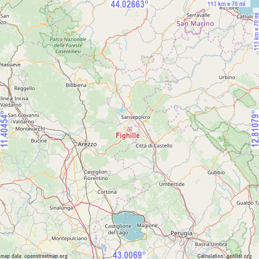
Fighille GPS coordinates[2]
43° 31' 8.112" North, 12° 6' 27.576" East
| Map corner | latitude | longitude |
|---|---|---|
| Upper-left | 44.02663°, | 11.40454° |
| Center: | 43.51892°, | 12.10766° |
| Lower-right: | 43.0069°, | 12.81079° |
| Map W x H: | 113.4×113.4 km | = 70.5×70.5mi |
| max Lat: | 47.04031° ⇑59.7% North |
| Fighille: | 43.51892° |
| min Lat: | ⇓40.3% South 35.50142° |
| min Long | Fighille | max Long |
| 6.69888° | 12.10766° | 18.48682° |
| W 57.4%⇐ | ⇒42.6% E |
Elevation
Elevation of Fighille is 307 m = 1007 ft, and this is 0.30000000000001 m = 1 ft above average elevation for this country.
| Max E: |
2085 m = 6841 ft | 38.9% |
| Fighille | 307 m 1007 ft | |
| Avg. | 306.7 m = 1006 ft | |
Min E: |
-4 m = -13 ft | 61.1% |
See also: Italy elevation on elevation.city.
Geographical zone
Fighille is located in North temperate zone (between Tropic of Cancer and the Arctic Circle). Distance of this Northern Tropic circle is 2232.9 km =1387.5 mi to South.| Distance of | km | miles | from Fighille |
|---|---|---|---|
| North Pole | 5168.2 | 3211.4 | to North |
| Arctic Circle | 2562.3 | 1592.1 | to North |
| Tropic Cancer | 2232.9 | 1387.5 | to South |
| Equator | 4838.9 | 3006.8 | to South |


Nearby cities:
15 places around Fighille: (largest is in red/bold)
• Anghiari
4.7 km =2.9 mi,  301°
301°
• Cerbara
8.6 km =5.3 mi,  104°
104°
• Citerna
2.3 km =1.4 mi,  167°
167°
• Città di Castello
12 km =7.5 mi,  119°
119°
• Lerchi
8.8 km =5.5 mi, 122°
• Monte Santa Maria Tiberina
10.1 km =6.3 mi,  154°
154°
• Monterchi
3.5 km =2.2 mi,  176°
176°
• Palazzo del Pero
15.2 km =9.4 mi,  224°
224°
• Piosina
8.1 km =5 mi,  114°
114°
• Pistrino
3.7 km =2.3 mi, 106°
• Pitigliano
16 km =9.9 mi,  241°
241°
• San Giustino
6.3 km =3.9 mi,  60°
60°
• Sansepolcro
6.5 km =4 mi,  22°
22°
• Santa Fiora
4.6 km =2.9 mi,  5°
5°
• Selci-Lama
8.5 km =5.3 mi,  91°
91°
Sources, notices
• [Note1] Compared only with cities in Italy existing in our database
• [Src1] Map data: © OpenStreetMap contributors (CC-BY-SA)
• [Src2] Other city data from geonames.org with taken over terms of usage.
• [Src3] Geographical zone / Annual Mean Temperature by Robert A. Rohde @ Wikipedia
