Prato geodata
Prato (Tuscany) is a seat of a second-order administrative division; located in Italy in Europe/Rome (GMT+2) time zone. With population of 181,820 people, there are 15 cities with bigger population in this country. Compared to other cities in Italy, 56% of cities are located further ↑North; 55.9% of cities are located further →East and 75.6% of cities have higher elevation than Prato. Note1


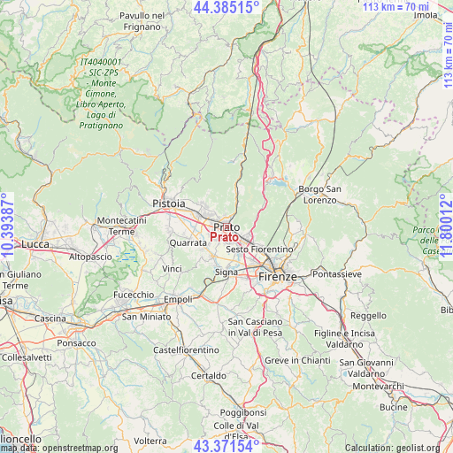
Prato GPS coordinates[2]
43° 52' 49.8" North, 11° 5' 49.164" East
| Map corner | latitude | longitude |
|---|---|---|
| Upper-left | 44.38515°, | 10.39387° |
| Center: | 43.8805°, | 11.09699° |
| Lower-right: | 43.37154°, | 11.80012° |
| Map W x H: | 112.7×112.7 km | = 70×70mi |
| max Lat: | 47.04031° ⇑56% North |
| Prato: | 43.8805° |
| min Lat: | ⇓44% South 35.50142° |
| min Long | Prato | max Long |
| 6.69888° | 11.09699° | 18.48682° |
| W 44.1%⇐ | ⇒55.9% E |
Elevation
Elevation of Prato is 71 m = 233 ft, and this is 235.7 m = 773 ft below average elevation for this country.
| Max E: |
2085 m = 6841 ft | 75.6% |
| Avg. | 306.7 m = 1006 ft | |
| Prato | 71 m = 233 ft | |
Min E: |
-4 m = -13 ft | 24.4% |
See also: Prato elevation on elevation.city.
Geographical zone
Prato is located in North temperate zone (between Tropic of Cancer and the Arctic Circle). Distance of this Northern Tropic circle is 2273.1 km =1412.4 mi to South.| Distance of | km | miles | from Prato |
|---|---|---|---|
| North Pole | 5128 | 3186.4 | to North |
| Arctic Circle | 2522.1 | 1567.2 | to North |
| Tropic Cancer | 2273.1 | 1412.4 | to South |
| Equator | 4879.1 | 3031.7 | to South |


Nearby cities:
15 places around Prato: (largest is in red/bold)
• Agliana
7.7 km =4.8 mi,  288°
288°
• Calenzano
6.2 km =3.9 mi,  117°
117°
• Campi Bisenzio
6.8 km =4.2 mi,  156°
156°
• Carraia
7 km =4.3 mi,  76°
76°
• Caserana
6.9 km =4.3 mi,  254°
254°
• Casini
8.2 km =5.1 mi, 252°
• Catena
7.7 km =4.8 mi,  236°
236°
• Fornacelle
6.9 km =4.3 mi,  314°
314°
• Il Rosi
4.4 km =2.7 mi,  126°
126°
• Montemurlo
7 km =4.3 mi,  317°
317°
• Poggetto
7.5 km =4.7 mi,  218°
218°
• Poggio A Caiano
8.3 km =5.2 mi,  206°
206°
• Seano
8.2 km =5.1 mi,  227°
227°
• Stazione
7.6 km =4.7 mi,  299°
299°
• Vignole-Olmi
8.7 km =5.4 mi,  260°
260°
Sources, notices
• [Note1] Compared only with cities in Italy existing in our database
• [Src1] Map data: © OpenStreetMap contributors (CC-BY-SA)
• [Src2] Other city data from geonames.org with taken over terms of usage.
• [Src3] Geographical zone / Annual Mean Temperature by Robert A. Rohde @ Wikipedia
