Calenzano geodata
Calenzano (Tuscany) is a seat of a third-order administrative division; located in Italy in Europe/Rome (GMT+2) time zone. With population of 12,623 people, there are 736 cities with bigger population in this country. Compared to other cities in Italy, 56.3% of cities are located further ↑North; 54.9% of cities are located further →East and 78.6% of cities have higher elevation than Calenzano. Note1


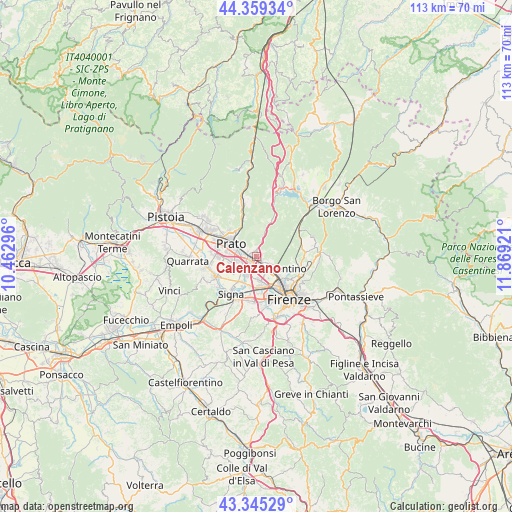
Calenzano GPS coordinates[2]
43° 51' 16.092" North, 11° 9' 57.888" East
| Map corner | latitude | longitude |
|---|---|---|
| Upper-left | 44.35934°, | 10.46296° |
| Center: | 43.85447°, | 11.16608° |
| Lower-right: | 43.34529°, | 11.86921° |
| Map W x H: | 112.8×112.8 km | = 70.1×70.1mi |
| max Lat: | 47.04031° ⇑56.3% North |
| Calenzano: | 43.85447° |
| min Lat: | ⇓43.7% South 35.50142° |
| min Long | Calenzano | max Long |
| 6.69888° | 11.16608° | 18.48682° |
| W 45.1%⇐ | ⇒54.9% E |
Elevation
Elevation of Calenzano is 56 m = 184 ft, and this is 250.7 m = 823 ft below average elevation for this country.
| Max E: |
2085 m = 6841 ft | 78.6% |
| Avg. | 306.7 m = 1006 ft | |
| Calenzano | 56 m = 184 ft | |
Min E: |
-4 m = -13 ft | 21.4% |
See also: Italy elevation on elevation.city.
Geographical zone
Calenzano is located in North temperate zone (between Tropic of Cancer and the Arctic Circle). Distance of this Northern Tropic circle is 2270.2 km =1410.6 mi to South.| Distance of | km | miles | from Calenzano |
|---|---|---|---|
| North Pole | 5130.9 | 3188.2 | to North |
| Arctic Circle | 2525 | 1569 | to North |
| Tropic Cancer | 2270.2 | 1410.6 | to South |
| Equator | 4876.2 | 3029.9 | to South |


Nearby cities:
15 places around Calenzano: (largest is in red/bold)
• Campi Bisenzio
4.4 km =2.7 mi,  220°
220°
• Carraia
4.7 km =2.9 mi,  15°
15°
• Florence
10.6 km =6.6 mi,  142°
142°
• Il Rosi
2 km =1.2 mi,  278°
278°
• Lastra a Signa
10.3 km =6.4 mi,  204°
204°
• Mantignano-Ugnano
8.1 km =5 mi,  178°
178°
• Pian di San Bartolo-Trespiano
10.1 km =6.3 mi,  102°
102°
• Poggetto
10.7 km =6.6 mi,  253°
253°
• Poggio A Caiano
10.2 km =6.3 mi,  243°
243°
• Prato
6.2 km =3.9 mi,  297°
297°
• Pratolino
10.7 km =6.6 mi,  85°
85°
• San Donnino
6.7 km =4.2 mi,  193°
193°
• San Mauro
7.5 km =4.7 mi,  206°
206°
• Sesto Fiorentino
3.7 km =2.3 mi,  133°
133°
• Signa
8.4 km =5.2 mi, 216°
Sources, notices
• [Note1] Compared only with cities in Italy existing in our database
• [Src1] Map data: © OpenStreetMap contributors (CC-BY-SA)
• [Src2] Other city data from geonames.org with taken over terms of usage.
• [Src3] Geographical zone / Annual Mean Temperature by Robert A. Rohde @ Wikipedia
