Ciaculli geodata
Ciaculli (Sicily) is a populated place; located in Italy in Europe/Rome (GMT+2) time zone. With population of 6,307 people, there are 1549 cities with bigger population in this country. Compared to other cities in Italy, 95.9% of cities are located further ↑North; 72.5% of cities are located further ←West and 79% of cities have higher elevation than Ciaculli. Note1
Administrative division(s):
- Level 1: Sicily
- Level 2: Palermo
- Level 3: Palermo
- Level 4: Circoscrizione III


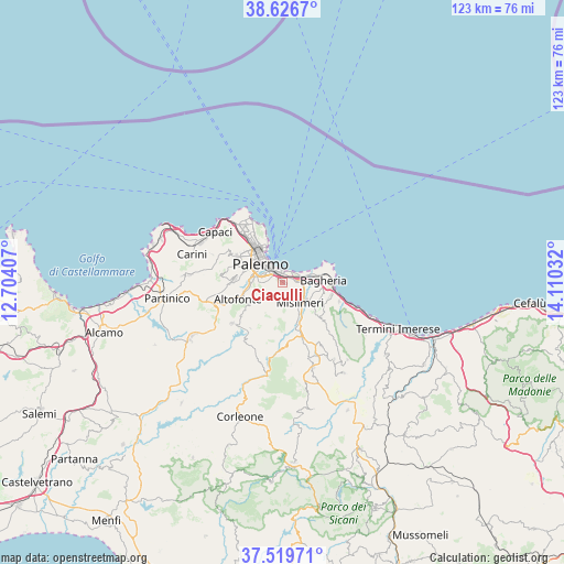
Ciaculli GPS coordinates[2]
38° 4' 31.08" North, 13° 24' 25.884" East
| Map corner | latitude | longitude |
|---|---|---|
| Upper-left | 38.6267°, | 12.70407° |
| Center: | 38.0753°, | 13.40719° |
| Lower-right: | 37.51971°, | 14.11032° |
| Map W x H: | 123.1×123.1 km | = 76.5×76.5mi |
| max Lat: | 47.04031° ⇑95.9% North |
| Ciaculli: | 38.0753° |
| min Lat: | ⇓4.1% South 35.50142° |
| min Long | Ciaculli | max Long |
| 6.69888° | 13.40719° | 18.48682° |
| W 72.5%⇐ | ⇒27.5% E |
Elevation
Elevation of Ciaculli is 54 m = 177 ft, and this is 252.7 m = 829 ft below average elevation for this country.
| Max E: |
2085 m = 6841 ft | 79% |
| Avg. | 306.7 m = 1006 ft | |
| Ciaculli | 54 m = 177 ft | |
Min E: |
-4 m = -13 ft | 21% |
See also: Italy elevation on elevation.city.
Geographical zone
Ciaculli is located in North temperate zone (between Tropic of Cancer and the Arctic Circle). Distance of this Northern Tropic circle is 1627.7 km =1011.4 mi to South.| Distance of | km | miles | from Ciaculli |
|---|---|---|---|
| North Pole | 5773.5 | 3587.5 | to North |
| Arctic Circle | 3167.6 | 1968.3 | to North |
| Tropic Cancer | 1627.7 | 1011.4 | to South |
| Equator | 4233.6 | 2630.6 | to South |


Nearby cities:
15 places around Ciaculli: (largest is in red/bold)
• Altofonte
10.5 km =6.5 mi,  250°
250°
• Bagheria
9.2 km =5.7 mi,  87°
87°
• Belmonte Mezzagno
3.5 km =2.2 mi,  202°
202°
• Casteldaccia
11.1 km =6.9 mi,  103°
103°
• Ficarazzelli-Bagni Italia
3.8 km =2.4 mi,  71°
71°
• Ficarazzi
5.3 km =3.3 mi, 69°
• Misilmeri
6 km =3.7 mi,  143°
143°
• Monreale
10.3 km =6.4 mi,  273°
273°
• Palermo
8.9 km =5.5 mi,  315°
315°
• Piano Maglio-Blandino
8.8 km =5.5 mi,  257°
257°
• Piano Pantaleo
4.3 km =2.7 mi,  145°
145°
• Portella di Mare
4.8 km =3 mi, 92°
• Santa Flavia
11.5 km =7.1 mi, 73°
• Villa Ciambra
7.8 km =4.8 mi, 258°
• Villabate
3.1 km =1.9 mi,  84°
84°
Sources, notices
• [Note1] Compared only with cities in Italy existing in our database
• [Src1] Map data: © OpenStreetMap contributors (CC-BY-SA)
• [Src2] Other city data from geonames.org with taken over terms of usage.
• [Src3] Geographical zone / Annual Mean Temperature by Robert A. Rohde @ Wikipedia
