Bagheria geodata
Bagheria (Sicily) is a seat of a third-order administrative division; located in Italy in Europe/Rome (GMT+2) time zone. With population of 52,952 people, there are 107 cities with bigger population in this country. Compared to other cities in Italy, 95.9% of cities are located further ↑North; 73.7% of cities are located further ←West and 73.6% of cities have higher elevation than Bagheria. Note1


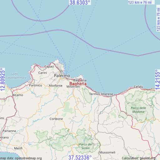
Bagheria GPS coordinates[2]
38° 4' 44.112" North, 13° 30' 44.532" East
| Map corner | latitude | longitude |
|---|---|---|
| Upper-left | 38.6303°, | 12.80925° |
| Center: | 38.07892°, | 13.51237° |
| Lower-right: | 37.52336°, | 14.2155° |
| Map W x H: | 123.1×123.1 km | = 76.5×76.5mi |
| max Lat: | 47.04031° ⇑95.9% North |
| Bagheria: | 38.07892° |
| min Lat: | ⇓4.1% South 35.50142° |
| min Long | Bagheria | max Long |
| 6.69888° | 13.51237° | 18.48682° |
| W 73.7%⇐ | ⇒26.3% E |
Elevation
Elevation of Bagheria is 80 m = 262 ft, and this is 226.7 m = 744 ft below average elevation for this country.
| Max E: |
2085 m = 6841 ft | 73.6% |
| Avg. | 306.7 m = 1006 ft | |
| Bagheria | 80 m = 262 ft | |
Min E: |
-4 m = -13 ft | 26.4% |
See also: Bagheria elevation on elevation.city.
Geographical zone
Bagheria is located in North temperate zone (between Tropic of Cancer and the Arctic Circle). Distance of this Northern Tropic circle is 1628.1 km =1011.7 mi to South.| Distance of | km | miles | from Bagheria |
|---|---|---|---|
| North Pole | 5773.1 | 3587.2 | to North |
| Arctic Circle | 3167.2 | 1968 | to North |
| Tropic Cancer | 1628.1 | 1011.7 | to South |
| Equator | 4234 | 2630.9 | to South |


Nearby cities:
15 places around Bagheria: (largest is in red/bold)
• Altavilla Milicia
5.6 km =3.5 mi,  144°
144°
• Belmonte Mezzagno
11.1 km =6.9 mi,  251°
251°
• Bolognetta
12.9 km =8 mi,  202°
202°
• Casteldaccia
3.5 km =2.2 mi,  152°
152°
• Ciaculli
9.2 km =5.7 mi,  267°
267°
• Ficarazzelli-Bagni Italia
5.7 km =3.5 mi,  278°
278°
• Ficarazzi
4.5 km =2.8 mi,  289°
289°
• Marineo
16.4 km =10.2 mi,  210°
210°
• Misilmeri
7.7 km =4.8 mi,  227°
227°
• Piano Pantaleo
7.8 km =4.8 mi,  239°
239°
• Portella di Mare
4.5 km =2.8 mi,  261°
261°
• Santa Flavia
3.4 km =2.1 mi,  32°
32°
• Torre Colonna-Sperone
7.7 km =4.8 mi, 135°
• Trabia
13.5 km =8.4 mi,  127°
127°
• Villabate
6.1 km =3.8 mi, 268°
Sources, notices
• [Note1] Compared only with cities in Italy existing in our database
• [Src1] Map data: © OpenStreetMap contributors (CC-BY-SA)
• [Src2] Other city data from geonames.org with taken over terms of usage.
• [Src3] Geographical zone / Annual Mean Temperature by Robert A. Rohde @ Wikipedia
