San Nicolò a Tordino geodata
San Nicolò a Tordino (Abruzzo) is a populated place; located in Italy in Europe/Rome (GMT+2) time zone. With population of 5,092 people, there are 1928 cities with bigger population in this country. Compared to other cities in Italy, 65.2% of cities are located further ↑North; 76.6% of cities are located further ←West and 63.4% of cities have higher elevation than San Nicolò a Tordino. Note1
Current local time in San Nicolò a Tordino:
11:49 PM, WednesdayDifference from your time zone: hours


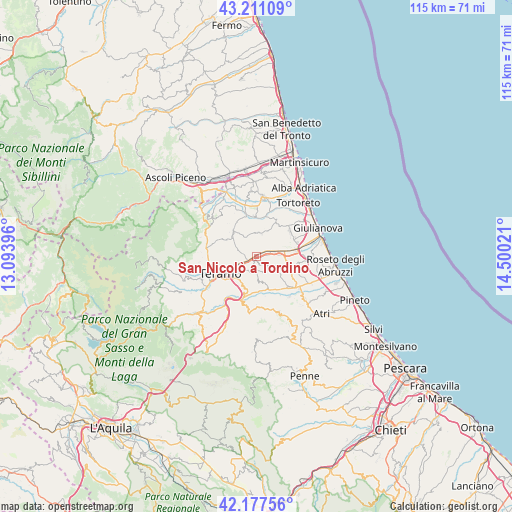
San Nicolò a Tordino GPS coordinates[2]
42° 41' 47.328" North, 13° 47' 49.488" East
| Map corner | latitude | longitude |
|---|---|---|
| Upper-left | 43.21109°, | 13.09396° |
| Center: | 42.69648°, | 13.79708° |
| Lower-right: | 42.17756°, | 14.50021° |
| Map W x H: | 114.9×114.9 km | = 71.4×71.4mi |
| max Lat: | 47.04031° ⇑65.2% North |
| San Nicolò a Tordino: | 42.69648° |
| min Lat: | ⇓34.8% South 35.50142° |
| min Long | San Nicolò a T | max Long |
| 6.69888° | 13.79708° | 18.48682° |
| W 76.6%⇐ | ⇒23.4% E |
Elevation
Elevation of San Nicolò a Tordino is 138 m = 453 ft, and this is 168.7 m = 553 ft below average elevation for this country.
| Max E: |
2085 m = 6841 ft | 63.4% |
| Avg. | 306.7 m = 1006 ft | |
| San Nicolò a Tordino | 138 m = 453 ft | |
Min E: |
-4 m = -13 ft | 36.6% |
See also: Italy elevation on elevation.city.
Geographical zone
San Nicolò a Tordino is located in North temperate zone (between Tropic of Cancer and the Arctic Circle). Distance of this Northern Tropic circle is 2141.5 km =1330.7 mi to South.| Distance of | km | miles | from San Nicolò a Tordino |
|---|---|---|---|
| North Pole | 5259.7 | 3268.2 | to North |
| Arctic Circle | 2653.8 | 1649 | to North |
| Tropic Cancer | 2141.5 | 1330.7 | to South |
| Equator | 4747.4 | 2949.9 | to South |


Nearby cities:
15 places around San Nicolò a Tordino: (largest is in red/bold)
• Bellante
5.3 km =3.3 mi,  4°
4°
• Bellante Stazione
3.6 km =2.2 mi,  72°
72°
• Cannelli
7.7 km =4.8 mi,  261°
261°
• Canzano
5.7 km =3.5 mi,  174°
174°
• Castellalto
2.9 km =1.8 mi,  137°
137°
• Castelnuovo Vomano
8.6 km =5.3 mi,  149°
149°
• Colle Santa Maria-Varano
6.3 km =3.9 mi,  278°
278°
• Colleatterrato Alto
5.8 km =3.6 mi,  251°
251°
• Nepezzano
3.4 km =2.1 mi, 257°
• Petriccione
3.4 km =2.1 mi,  86°
86°
• Piano d'Accio
3.5 km =2.2 mi, 246°
• Sant'Atto
1.5 km =0.9 mi,  34°
34°
• Sant'Onofrio-Floriano
8.7 km =5.4 mi,  326°
326°
• Teramo
8.9 km =5.5 mi,  243°
243°
• Villa Zaccheo
4.1 km =2.5 mi, 89°
Sources, notices
• [Note1] Compared only with cities in Italy existing in our database
• [Src1] Map data: © OpenStreetMap contributors (CC-BY-SA)
• [Src2] Other city data from geonames.org with taken over terms of usage.
• [Src3] Geographical zone / Annual Mean Temperature by Robert A. Rohde @ Wikipedia
