Sant'Onofrio-Floriano geodata
Sant'Onofrio-Floriano (Abruzzo) is a populated place; located in Italy in Europe/Rome (GMT+2) time zone. With population of 909 people, there are 7095 cities with bigger population in this country. Compared to other cities in Italy, 64.9% of cities are located further ↑North; 76% of cities are located further ←West and 61.3% of cities have higher elevation than Sant'Onofrio-Floriano. Note1
Current local time in Sant'Onofrio-Floriano:
11:49 PM, WednesdayDifference from your time zone: hours


Sant'Onofrio-Floriano GPS coordinates[2]
42° 45' 41.436" North, 13° 44' 14.748" East
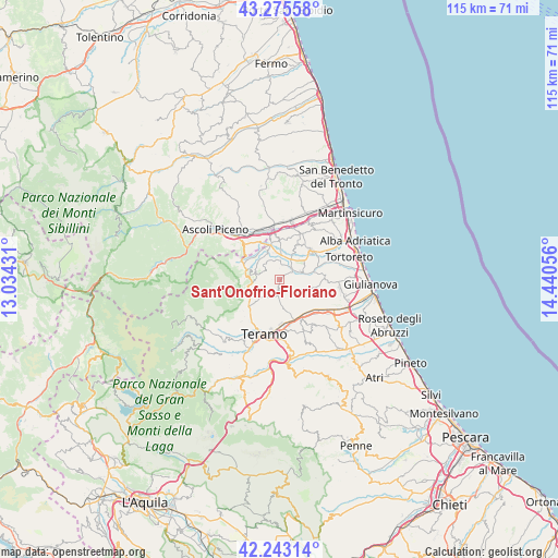
| Map corner | latitude | longitude |
|---|---|---|
| Upper-left | 43.27558°, | 13.03431° |
| Center: | 42.76151°, | 13.73743° |
| Lower-right: | 42.24314°, | 14.44056° |
| Map W x H: | 114.8×114.8 km | = 71.3×71.3mi |
| max Lat: | 47.04031° ⇑64.9% North |
| Sant'Onofrio-Floriano: | 42.76151° |
| min Lat: | ⇓35.1% South 35.50142° |
| min Long | Sant'Onofrio-Fl | max Long |
| 6.69888° | 13.73743° | 18.48682° |
| W 76%⇐ | ⇒24% E |
Elevation
Elevation of Sant'Onofrio-Floriano is 153 m = 502 ft, and this is 153.7 m = 504 ft below average elevation for this country.
| Max E: |
2085 m = 6841 ft | 61.3% |
| Avg. | 306.7 m = 1006 ft | |
| Sant'Onofrio-Floriano | 153 m = 502 ft | |
Min E: |
-4 m = -13 ft | 38.7% |
See also: Italy elevation on elevation.city.
Geographical zone
Sant'Onofrio-Floriano is located in North temperate zone (between Tropic of Cancer and the Arctic Circle). Distance of this Northern Tropic circle is 2148.7 km =1335.1 mi to South.| Distance of | km | miles | from Sant'Onofrio-Floriano |
|---|---|---|---|
| North Pole | 5252.4 | 3263.7 | to North |
| Arctic Circle | 2646.5 | 1644.5 | to North |
| Tropic Cancer | 2148.7 | 1335.1 | to South |
| Equator | 4754.6 | 2954.4 | to South |


Nearby cities:
15 places around Sant'Onofrio-Floriano: (largest is in red/bold)
• Ancarano
8.5 km =5.3 mi,  5°
5°
• Bellante
5.6 km =3.5 mi,  109°
109°
• Campli
5.6 km =3.5 mi,  226°
226°
• Castelnuovo
4.9 km =3 mi,  223°
223°
• Civitella del Tronto
5.2 km =3.2 mi,  284°
284°
• Colle Santa Maria-Varano
6.4 km =4 mi,  192°
192°
• Nepezzano
8.1 km =5 mi,  168°
168°
• Piano d'Accio
8.8 km =5.5 mi, 169°
• San Nicolò a Tordino
8.7 km =5.4 mi,  146°
146°
• Sant'Atto
8.3 km =5.2 mi,  136°
136°
• Sant'Egidio alla Vibrata
6.3 km =3.9 mi,  348°
348°
• Sant'Omero
5.3 km =3.3 mi,  52°
52°
• Santa Croce
4.1 km =2.5 mi, 351°
• Torano Nuovo
7.6 km =4.7 mi,  25°
25°
• Villa Lempa
8.4 km =5.2 mi,  295°
295°
Sources, notices
• [Note1] Compared only with cities in Italy existing in our database
• [Src1] Map data: © OpenStreetMap contributors (CC-BY-SA)
• [Src2] Other city data from geonames.org with taken over terms of usage.
• [Src3] Geographical zone / Annual Mean Temperature by Robert A. Rohde @ Wikipedia
