Sant'Atto geodata
Sant'Atto (Abruzzo) is a populated place; located in Italy in Europe/Rome (GMT+2) time zone. With population of 669 people, there are 8494 cities with bigger population in this country. Compared to other cities in Italy, 65.1% of cities are located further ↑North; 76.7% of cities are located further ←West and 53% of cities have higher elevation than Sant'Atto. Note1


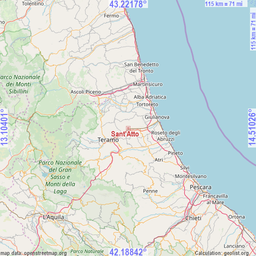
Sant'Atto GPS coordinates[2]
42° 42' 26.1" North, 13° 48' 25.668" East
| Map corner | latitude | longitude |
|---|---|---|
| Upper-left | 43.22178°, | 13.10401° |
| Center: | 42.70725°, | 13.80713° |
| Lower-right: | 42.18842°, | 14.51026° |
| Map W x H: | 114.9×114.9 km | = 71.4×71.4mi |
| max Lat: | 47.04031° ⇑65.1% North |
| Sant'Atto: | 42.70725° |
| min Lat: | ⇓34.9% South 35.50142° |
| min Long | Sant'Atto | max Long |
| 6.69888° | 13.80713° | 18.48682° |
| W 76.7%⇐ | ⇒23.3% E |
Elevation
Elevation of Sant'Atto is 216 m = 709 ft, and this is 90.7 m = 298 ft below average elevation for this country.
| Max E: |
2085 m = 6841 ft | 53% |
| Avg. | 306.7 m = 1006 ft | |
| Sant'Atto | 216 m = 709 ft | |
Min E: |
-4 m = -13 ft | 47% |
See also: Italy elevation on elevation.city.
Geographical zone
Sant'Atto is located in North temperate zone (between Tropic of Cancer and the Arctic Circle). Distance of this Northern Tropic circle is 2142.7 km =1331.4 mi to South.| Distance of | km | miles | from Sant'Atto |
|---|---|---|---|
| North Pole | 5258.5 | 3267.5 | to North |
| Arctic Circle | 2652.6 | 1648.2 | to North |
| Tropic Cancer | 2142.7 | 1331.4 | to South |
| Equator | 4748.6 | 2950.6 | to South |


Nearby cities:
15 places around Sant'Atto: (largest is in red/bold)
• Bellante
4.1 km =2.5 mi,  354°
354°
• Bellante Stazione
2.6 km =1.6 mi,  91°
91°
• Cannelli
8.7 km =5.4 mi,  254°
254°
• Canzano
6.9 km =4.3 mi,  182°
182°
• Castellalto
3.5 km =2.2 mi,  161°
161°
• Colle Santa Maria-Varano
7.1 km =4.4 mi,  267°
267°
• Colleatterrato Alto
7 km =4.3 mi,  244°
244°
• Mosciano Sant'Angelo
8 km =5 mi,  56°
56°
• Nepezzano
4.6 km =2.9 mi, 245°
• Notaresco
9.1 km =5.7 mi,  127°
127°
• Petriccione
2.8 km =1.7 mi,  111°
111°
• Piano d'Accio
4.8 km =3 mi, 237°
• San Nicolò a Tordino
1.5 km =0.9 mi,  214°
214°
• Sant'Onofrio-Floriano
8.3 km =5.2 mi,  316°
316°
• Villa Zaccheo
3.5 km =2.2 mi, 108°
Sources, notices
• [Note1] Compared only with cities in Italy existing in our database
• [Src1] Map data: © OpenStreetMap contributors (CC-BY-SA)
• [Src2] Other city data from geonames.org with taken over terms of usage.
• [Src3] Geographical zone / Annual Mean Temperature by Robert A. Rohde @ Wikipedia
