Canova-San Zeno geodata
Canova-San Zeno (Lombardy) is a seat of a third-order administrative division; located in Italy in Europe/Rome (GMT+2) time zone. With population of 4,915 people, there are 1983 cities with bigger population in this country. Compared to other cities in Italy, 82.3% of cities are located further ↓South; 74.5% of cities are located further →East and 57.7% of cities have lower elevation than Canova-San Zeno. Note1


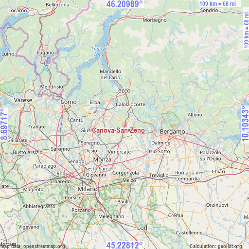
Canova-San Zeno GPS coordinates[2]
45° 43' 16.176" North, 9° 24' 1.08" East
| Map corner | latitude | longitude |
|---|---|---|
| Upper-left | 46.20989°, | 8.69717° |
| Center: | 45.72116°, | 9.4003° |
| Lower-right: | 45.22812°, | 10.10343° |
| Map W x H: | 109.2×109.2 km | = 67.9×67.9mi |
| max Lat: | 47.04031° ⇑17.7% North |
| Canova-San Zeno: | 45.72116° |
| min Lat: | ⇓82.3% South 35.50142° |
| min Long | Canova-San Zeno | max Long |
| 6.69888° | 9.4003° | 18.48682° |
| W 25.5%⇐ | ⇒74.5% E |
Elevation
Elevation of Canova-San Zeno is 284 m = 932 ft, and this is 22.7 m = 74 ft below average elevation for this country.
| Max E: |
2085 m = 6841 ft | 42.3% |
| Avg. | 306.7 m = 1006 ft | |
| Canova-San Zeno | 284 m = 932 ft | |
Min E: |
-4 m = -13 ft | 57.7% |
See also: Italy elevation on elevation.city.
Geographical zone
Canova-San Zeno is located in North temperate zone (between Tropic of Cancer and the Arctic Circle). Distance of this North polar circle is 2317.5 km =1440 mi to North.| Distance of | km | miles | from Canova-San Zeno |
|---|---|---|---|
| North Pole | 4923.3 | 3059.2 | to North |
| Arctic Circle | 2317.5 | 1440 | to North |
| Tropic Cancer | 2477.8 | 1539.6 | to South |
| Equator | 5083.7 | 3158.9 | to South |


Nearby cities:
15 places around Canova-San Zeno: (largest is in red/bold)
• Arlate
3.3 km =2.1 mi,  85°
85°
• Brivio
3.7 km =2.3 mi,  61°
61°
• Calco
1 km =0.6 mi,  70°
70°
• Cassina Fra Martino
2.6 km =1.6 mi,  98°
98°
• Cernusco Lombardone
3.4 km =2.1 mi,  181°
181°
• Imbersago
3.8 km =2.4 mi,  116°
116°
• Lomaniga
3.9 km =2.4 mi,  239°
239°
• Merate
4 km =2.5 mi,  156°
156°
• Montevecchia
2.3 km =1.4 mi,  220°
220°
• Monticello-Mondonico
1.7 km =1.1 mi,  343°
343°
• Olgiate Molgora
1 km =0.6 mi,  13°
13°
• Perego
3.4 km =2.1 mi,  302°
302°
• Quattro Strade
3.4 km =2.1 mi,  212°
212°
• Rovagnate
2.9 km =1.8 mi,  307°
307°
• Santa Maria Hoè
3.3 km =2.1 mi,  322°
322°
Sources, notices
• [Note1] Compared only with cities in Italy existing in our database
• [Src1] Map data: © OpenStreetMap contributors (CC-BY-SA)
• [Src2] Other city data from geonames.org with taken over terms of usage.
• [Src3] Geographical zone / Annual Mean Temperature by Robert A. Rohde @ Wikipedia
