Perego geodata
Perego (Lombardy) is a seat of a third-order administrative division; located in Italy in Europe/Rome (GMT+2) time zone. With population of 1,280 people, there are 5697 cities with bigger population in this country. Compared to other cities in Italy, 83% of cities are located further ↓South; 75.2% of cities are located further →East and 64.3% of cities have lower elevation than Perego. Note1
Administrative division(s):
- Level 1: Lombardy
- Level 2: Provincia di Lecco
- Level 3: La Valletta Brianza


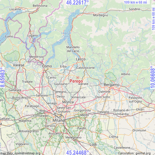
Perego GPS coordinates[2]
45° 44' 15.288" North, 9° 21' 46.62" East
| Map corner | latitude | longitude |
|---|---|---|
| Upper-left | 46.22617°, | 8.65983° |
| Center: | 45.73758°, | 9.36295° |
| Lower-right: | 45.24468°, | 10.06608° |
| Map W x H: | 109.1×109.1 km | = 67.8×67.8mi |
| max Lat: | 47.04031° ⇑17% North |
| Perego: | 45.73758° |
| min Lat: | ⇓83% South 35.50142° |
| min Long | Perego | max Long |
| 6.69888° | 9.36295° | 18.48682° |
| W 24.8%⇐ | ⇒75.2% E |
Elevation
Elevation of Perego is 337 m = 1106 ft, and this is 30.3 m = 99 ft above average elevation for this country.
| Max E: |
2085 m = 6841 ft | 35.7% |
| Perego | 337 m 1106 ft | |
| Avg. | 306.7 m = 1006 ft | |
Min E: |
-4 m = -13 ft | 64.3% |
See also: Italy elevation on elevation.city.
Geographical zone
Perego is located in North temperate zone (between Tropic of Cancer and the Arctic Circle). Distance of this North polar circle is 2315.6 km =1438.8 mi to North.| Distance of | km | miles | from Perego |
|---|---|---|---|
| North Pole | 4921.5 | 3058.1 | to North |
| Arctic Circle | 2315.6 | 1438.8 | to North |
| Tropic Cancer | 2479.6 | 1540.8 | to South |
| Equator | 5085.5 | 3160 | to South |


Nearby cities:
15 places around Perego: (largest is in red/bold)
• Barzanò
3.9 km =2.4 mi,  261°
261°
• Canova-San Zeno
3.4 km =2.1 mi,  122°
122°
• Castello di Brianza
2.8 km =1.7 mi,  330°
330°
• Colle Brianza
2.8 km =1.7 mi,  2°
2°
• Cologna-Caraverio
2.5 km =1.6 mi, 327°
• Dolzago
3.7 km =2.3 mi, 330°
• Lomaniga
3.8 km =2.4 mi,  186°
186°
• Montevecchia
3.8 km =2.4 mi,  158°
158°
• Monticello-Mondonico
2.4 km =1.5 mi,  94°
94°
• Nava
2.7 km =1.7 mi, 0°
• Olgiate Molgora
3.2 km =2 mi,  104°
104°
• Rovagnate
0.6 km =0.4 mi, 96°
• Santa Maria Hoè
1.2 km =0.7 mi,  50°
50°
• Sirtori
2.5 km =1.6 mi,  267°
267°
• Viganò
3.3 km =2.1 mi,  244°
244°
Sources, notices
• [Note1] Compared only with cities in Italy existing in our database
• [Src1] Map data: © OpenStreetMap contributors (CC-BY-SA)
• [Src2] Other city data from geonames.org with taken over terms of usage.
• [Src3] Geographical zone / Annual Mean Temperature by Robert A. Rohde @ Wikipedia
