Lomaniga geodata
Lomaniga (Lombardy) is a populated place; located in Italy in Europe/Rome (GMT+2) time zone. With population of 518 people, there are 9748 cities with bigger population in this country. Compared to other cities in Italy, 81.3% of cities are located further ↓South; 75.3% of cities are located further →East and 57% of cities have lower elevation than Lomaniga. Note1


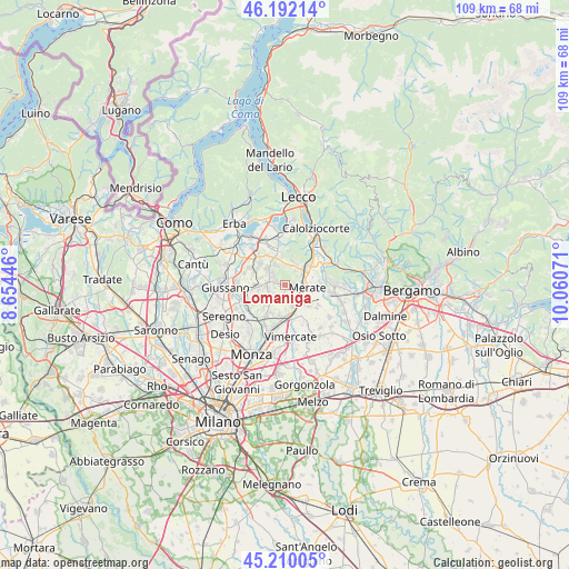
Lomaniga GPS coordinates[2]
45° 42' 11.7" North, 9° 21' 27.288" East
| Map corner | latitude | longitude |
|---|---|---|
| Upper-left | 46.19214°, | 8.65446° |
| Center: | 45.70325°, | 9.35758° |
| Lower-right: | 45.21005°, | 10.06071° |
| Map W x H: | 109.2×109.2 km | = 67.9×67.9mi |
| max Lat: | 47.04031° ⇑18.7% North |
| Lomaniga: | 45.70325° |
| min Lat: | ⇓81.3% South 35.50142° |
| min Long | Lomaniga | max Long |
| 6.69888° | 9.35758° | 18.48682° |
| W 24.7%⇐ | ⇒75.3% E |
Elevation
Elevation of Lomaniga is 278 m = 912 ft, and this is 28.7 m = 94 ft below average elevation for this country.
| Max E: |
2085 m = 6841 ft | 43% |
| Avg. | 306.7 m = 1006 ft | |
| Lomaniga | 278 m = 912 ft | |
Min E: |
-4 m = -13 ft | 57% |
See also: Italy elevation on elevation.city.
Geographical zone
Lomaniga is located in North temperate zone (between Tropic of Cancer and the Arctic Circle). Distance of this North polar circle is 2319.4 km =1441.2 mi to North.| Distance of | km | miles | from Lomaniga |
|---|---|---|---|
| North Pole | 4925.3 | 3060.4 | to North |
| Arctic Circle | 2319.4 | 1441.2 | to North |
| Tropic Cancer | 2475.8 | 1538.4 | to South |
| Equator | 5081.7 | 3157.6 | to South |


Nearby cities:
15 places around Lomaniga: (largest is in red/bold)
• Canova-San Zeno
3.9 km =2.4 mi,  59°
59°
• Casatenovo
3.5 km =2.2 mi,  255°
255°
• Cernusco Lombardone
3.5 km =2.2 mi,  113°
113°
• Maresso
1.8 km =1.1 mi,  184°
184°
• Missaglia
1.8 km =1.1 mi,  281°
281°
• Montevecchia
1.8 km =1.1 mi,  82°
82°
• Monticello
3.5 km =2.2 mi,  287°
287°
• Monticello Brianza
3.3 km =2.1 mi, 282°
• Osnago
4.1 km =2.5 mi,  139°
139°
• Perego
3.8 km =2.4 mi,  6°
6°
• Quattro Strade
1.7 km =1.1 mi,  119°
119°
• Rogoredo-Valaperta-Rimoldo
3.5 km =2.2 mi,  213°
213°
• Rovagnate
3.9 km =2.4 mi,  15°
15°
• Sirtori
4.2 km =2.6 mi,  330°
330°
• Viganò
3.5 km =2.2 mi,  313°
313°
Sources, notices
• [Note1] Compared only with cities in Italy existing in our database
• [Src1] Map data: © OpenStreetMap contributors (CC-BY-SA)
• [Src2] Other city data from geonames.org with taken over terms of usage.
• [Src3] Geographical zone / Annual Mean Temperature by Robert A. Rohde @ Wikipedia
