Roè geodata
Roè (Lombardy) is a seat of a third-order administrative division; located in Italy in Europe/Rome (GMT+2) time zone. With population of 4,058 people, there are 2363 cities with bigger population in this country. Compared to other cities in Italy, 78.1% of cities are located further ↓South; 62.9% of cities are located further →East and 50% of cities have lower elevation than Roè. Note1


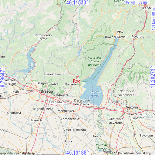
Roè GPS coordinates[2]
45° 37' 32.736" North, 10° 29' 58.56" East
| Map corner | latitude | longitude |
|---|---|---|
| Upper-left | 46.11533°, | 9.79647° |
| Center: | 45.62576°, | 10.4996° |
| Lower-right: | 45.13188°, | 11.20273° |
| Map W x H: | 109.3×109.3 km | = 67.9×67.9mi |
| max Lat: | 47.04031° ⇑21.9% North |
| Roè: | 45.62576° |
| min Lat: | ⇓78.1% South 35.50142° |
| min Long | Roè | max Long |
| 6.69888° | 10.4996° | 18.48682° |
| W 37.1%⇐ | ⇒62.9% E |
Elevation
Elevation of Roè is 235 m = 771 ft, and this is 71.7 m = 235 ft below average elevation for this country.
| Max E: |
2085 m = 6841 ft | 50% |
| Avg. | 306.7 m = 1006 ft | |
| Roè | 235 m = 771 ft | |
Min E: |
-4 m = -13 ft | 50% |
See also: Italy elevation on elevation.city.
Geographical zone
Roè is located in North temperate zone (between Tropic of Cancer and the Arctic Circle). Distance of this North polar circle is 2328.1 km =1446.6 mi to North.| Distance of | km | miles | from Roè |
|---|---|---|---|
| North Pole | 4934 | 3065.8 | to North |
| Arctic Circle | 2328.1 | 1446.6 | to North |
| Tropic Cancer | 2467.2 | 1533 | to South |
| Equator | 5073.1 | 3152.3 | to South |


Nearby cities:
15 places around Roè: (largest is in red/bold)
• Carpeneda
3.6 km =2.2 mi,  314°
314°
• Castello
6.3 km =3.9 mi,  173°
173°
• Collio
1.5 km =0.9 mi,  25°
25°
• Cunettone-Villa
4.4 km =2.7 mi,  161°
161°
• Gardone Riviera
5.2 km =3.2 mi,  92°
92°
• Gavardo-Sopraponte
6 km =3.7 mi,  227°
227°
• Puegnago sul Garda
6.6 km =4.1 mi, 173°
• Raffa
6.6 km =4.1 mi, 159°
• Roè Volciano
1.8 km =1.1 mi,  209°
209°
• Salò
2.7 km =1.7 mi,  142°
142°
• San Biagio
5 km =3.1 mi, 214°
• San Felice del Benaco
6.4 km =4 mi, 138°
• San Giacomo
4 km =2.5 mi, 206°
• Villanuova sul Clisi
4.7 km =2.9 mi, 231°
• Vobarno
1.8 km =1.1 mi,  357°
357°
Sources, notices
• [Note1] Compared only with cities in Italy existing in our database
• [Src1] Map data: © OpenStreetMap contributors (CC-BY-SA)
• [Src2] Other city data from geonames.org with taken over terms of usage.
• [Src3] Geographical zone / Annual Mean Temperature by Robert A. Rohde @ Wikipedia
