Carcare geodata
Carcare (Liguria) is a seat of a third-order administrative division; located in Italy in Europe/Rome (GMT+2) time zone. With population of 5,537 people, there are 1773 cities with bigger population in this country. Compared to other cities in Italy, 51.1% of cities are located further ↑North; 90.2% of cities are located further →East and 66.4% of cities have lower elevation than Carcare. Note1


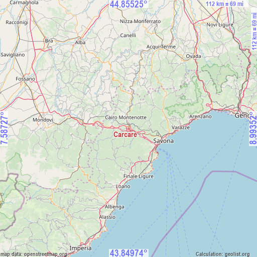
Carcare GPS coordinates[2]
44° 21' 16.74" North, 8° 17' 25.404" East
| Map corner | latitude | longitude |
|---|---|---|
| Upper-left | 44.85525°, | 7.58727° |
| Center: | 44.35465°, | 8.29039° |
| Lower-right: | 43.84974°, | 8.99352° |
| Map W x H: | 111.8×111.8 km | = 69.5×69.5mi |
| max Lat: | 47.04031° ⇑51.1% North |
| Carcare: | 44.35465° |
| min Lat: | ⇓48.9% South 35.50142° |
| min Long | Carcare | max Long |
| 6.69888° | 8.29039° | 18.48682° |
| W 9.8%⇐ | ⇒90.2% E |
Elevation
Elevation of Carcare is 357 m = 1171 ft, and this is 50.3 m = 165 ft above average elevation for this country.
| Max E: |
2085 m = 6841 ft | 33.6% |
| Carcare | 357 m 1171 ft | |
| Avg. | 306.7 m = 1006 ft | |
Min E: |
-4 m = -13 ft | 66.4% |
See also: Italy elevation on elevation.city.
Geographical zone
Carcare is located in North temperate zone (between Tropic of Cancer and the Arctic Circle). Distance of this Northern Tropic circle is 2325.9 km =1445.2 mi to South.| Distance of | km | miles | from Carcare |
|---|---|---|---|
| North Pole | 5075.3 | 3153.6 | to North |
| Arctic Circle | 2469.4 | 1534.4 | to North |
| Tropic Cancer | 2325.9 | 1445.2 | to South |
| Equator | 4931.8 | 3064.5 | to South |


Nearby cities:
15 places around Carcare: (largest is in red/bold)
• Altare
4.1 km =2.5 mi,  121°
121°
• Bormida
9.7 km =6 mi,  208°
208°
• Bormida-Genepro
8.2 km =5.1 mi,  298°
298°
• Cairo Montenotte
4.9 km =3 mi,  348°
348°
• Cengio Alto
8.1 km =5 mi,  294°
294°
• Cosseria
4.6 km =2.9 mi, 288°
• Dego
10.1 km =6.3 mi,  7°
7°
• Ferrania
2.3 km =1.4 mi,  78°
78°
• Mallare
7.3 km =4.5 mi,  175°
175°
• Millesimo
7 km =4.3 mi,  281°
281°
• Pallare
3.1 km =1.9 mi,  197°
197°
• Plodio
3.4 km =2.1 mi,  268°
268°
• Roccavignale
8 km =5 mi, 275°
• Rocchetta Cairo
8.3 km =5.2 mi, 5°
• Valzemola
9.3 km =5.8 mi, 276°
Sources, notices
• [Note1] Compared only with cities in Italy existing in our database
• [Src1] Map data: © OpenStreetMap contributors (CC-BY-SA)
• [Src2] Other city data from geonames.org with taken over terms of usage.
• [Src3] Geographical zone / Annual Mean Temperature by Robert A. Rohde @ Wikipedia
