Bubano geodata
Bubano (Emilia-Romagna) is a populated place; located in Italy in Europe/Rome (GMT+2) time zone. With population of 1,450 people, there are 5245 cities with bigger population in this country. Compared to other cities in Italy, 50.2% of cities are located further ↑North; 52.8% of cities are located further ←West and 90.1% of cities have higher elevation than Bubano. Note1


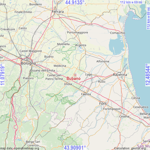
Bubano GPS coordinates[2]
44° 24' 48.276" North, 11° 46' 56.316" East
| Map corner | latitude | longitude |
|---|---|---|
| Upper-left | 44.9135°, | 11.07919° |
| Center: | 44.41341°, | 11.78231° |
| Lower-right: | 43.90901°, | 12.48544° |
| Map W x H: | 111.7×111.7 km | = 69.4×69.4mi |
| max Lat: | 47.04031° ⇑50.2% North |
| Bubano: | 44.41341° |
| min Lat: | ⇓49.8% South 35.50142° |
| min Long | Bubano | max Long |
| 6.69888° | 11.78231° | 18.48682° |
| W 52.8%⇐ | ⇒47.2% E |
Elevation
Elevation of Bubano is 18 m = 59 ft, and this is 288.7 m = 947 ft below average elevation for this country.
| Max E: |
2085 m = 6841 ft | 90.1% |
| Avg. | 306.7 m = 1006 ft | |
| Bubano | 18 m = 59 ft | |
Min E: |
-4 m = -13 ft | 9.9% |
See also: Italy elevation on elevation.city.
Geographical zone
Bubano is located in North temperate zone (between Tropic of Cancer and the Arctic Circle). Distance of this Northern Tropic circle is 2332.4 km =1449.3 mi to South.| Distance of | km | miles | from Bubano |
|---|---|---|---|
| North Pole | 5068.8 | 3149.6 | to North |
| Arctic Circle | 2462.9 | 1530.4 | to North |
| Tropic Cancer | 2332.4 | 1449.3 | to South |
| Equator | 4938.3 | 3068.5 | to South |


Nearby cities:
15 places around Bubano: (largest is in red/bold)
• Bagnara di Romagna
4.5 km =2.8 mi,  126°
126°
• Barbiano
8.7 km =5.4 mi,  107°
107°
• Castel Bolognese
10.5 km =6.5 mi,  172°
172°
• Castel Guelfo di Bologna
8.7 km =5.4 mi,  283°
283°
• Imola
8.2 km =5.1 mi,  222°
222°
• Lugo
10.3 km =6.4 mi,  85°
85°
• Massa Lombarda
4.8 km =3 mi,  39°
39°
• Mordano
2.7 km =1.7 mi, 132°
• San Patrizio
9.4 km =5.8 mi,  21°
21°
• San Prospero
5.5 km =3.4 mi,  185°
185°
• Sant'Agata sul Santerno
7.1 km =4.4 mi,  61°
61°
• Sasso Morelli
3.5 km =2.2 mi,  274°
274°
• Sesto Imolese
6.6 km =4.1 mi,  320°
320°
• Solarolo
7.9 km =4.9 mi,  139°
139°
• Villa San Martino
6.8 km =4.2 mi, 87°
Sources, notices
• [Note1] Compared only with cities in Italy existing in our database
• [Src1] Map data: © OpenStreetMap contributors (CC-BY-SA)
• [Src2] Other city data from geonames.org with taken over terms of usage.
• [Src3] Geographical zone / Annual Mean Temperature by Robert A. Rohde @ Wikipedia
